
Senja
Scenic Route
Complete Photographer's Guide
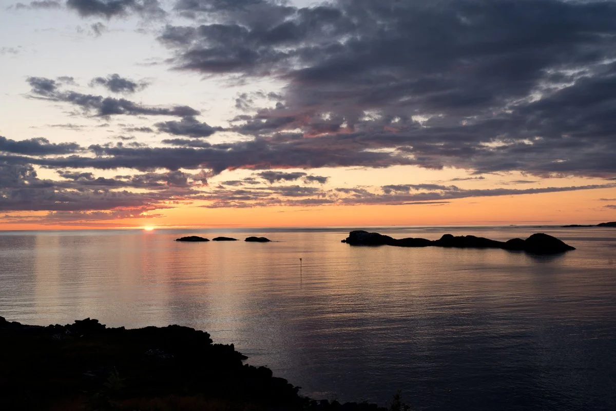
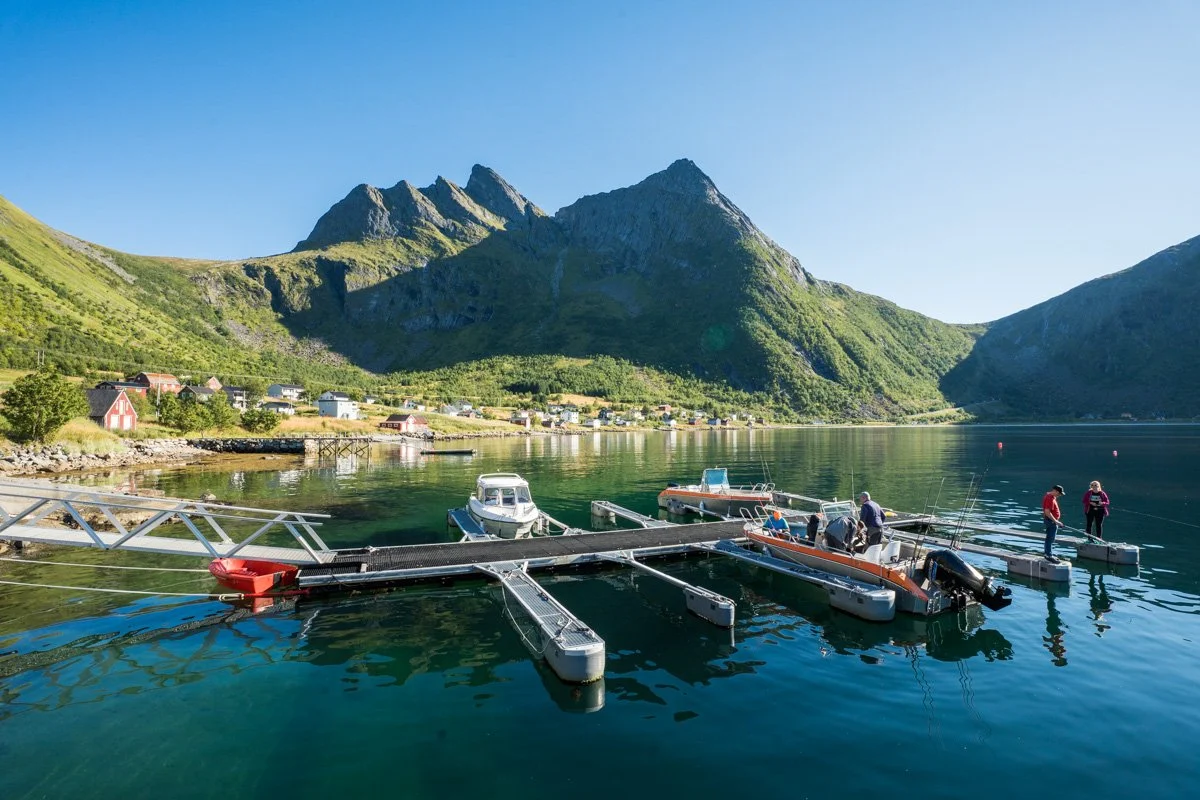
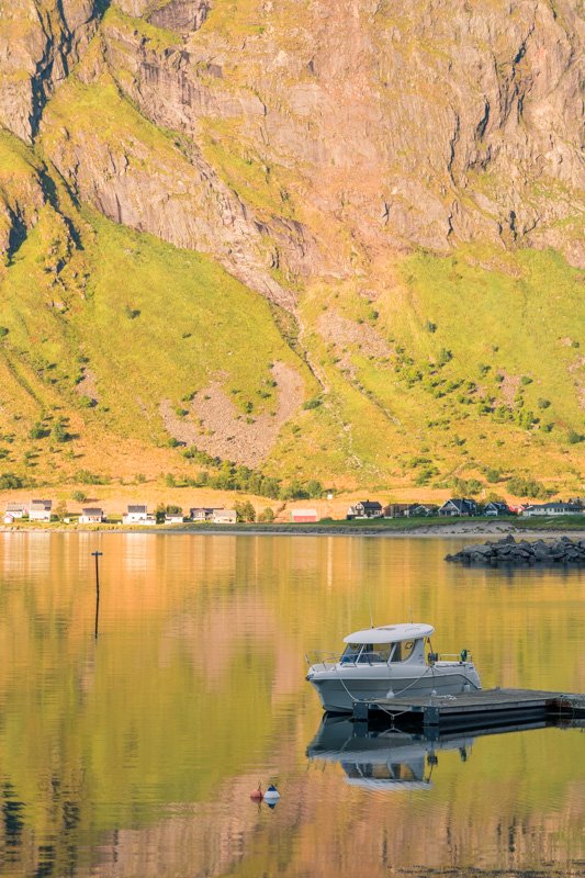
TungenesetSenja is one the largest islands in Norway. Deep in the Arctic, it’s about half way between Lofoten and Tromsø. Its coastline is designated as a National Tourist Scenic Route (Nasjonale turistveger) and it boasts majestic scenery. And yet it’s not well-known to landscape photographers. Should you visit? On this page, I describe the whole of Senja Scenic Route, pointing out stops I think will be of interest to photographers, to help you decide whether to visit and how to spend your time if you do.
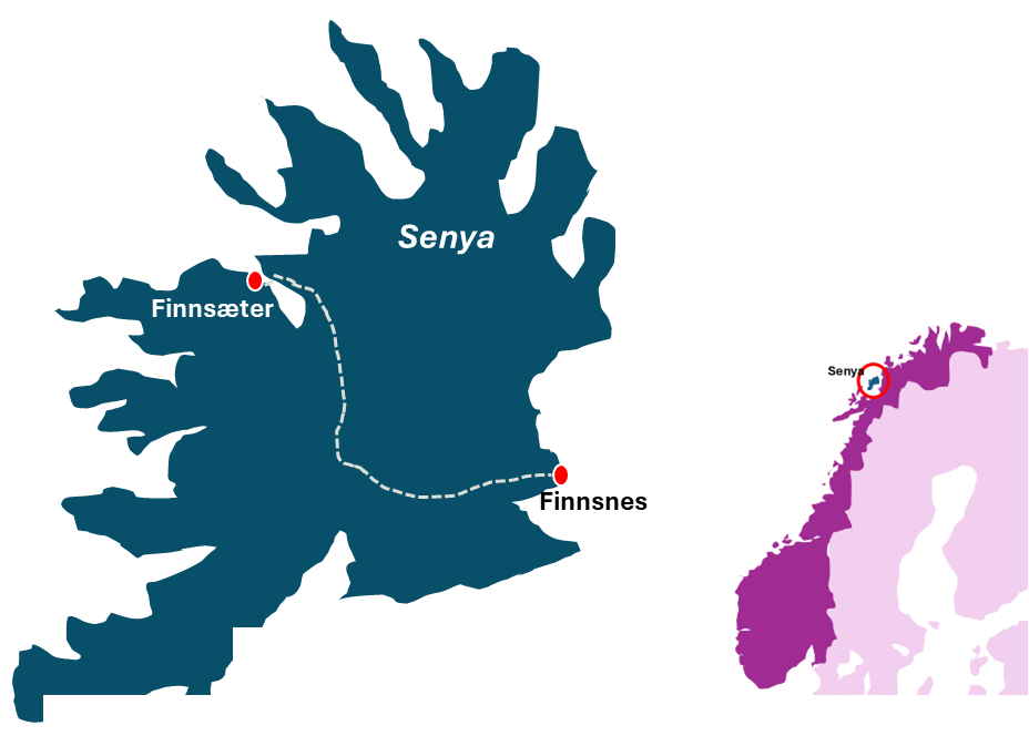
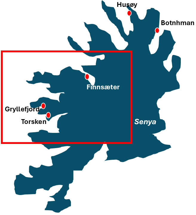
Senja is connected by a bridge to the town of Finnsnes, on the mainland. A few roads fan out across Senja from the bridge, but the main route cuts across the middle of the island towards Finnsæter. And the National Scenic Route.
In the guide below I’ve assumed that you are most likely to drive reach the Scenic Route by driving to Senja’s scenic coast from Finnsnes, and I’ve provided information following that route. I’ve visited Senja in late summer, and my descriptions are tailored to that time – but if you’re visiting at a different time of the year, check the sun’s position carefully to plan out your shooting as it may vary. Things to know about light in the Arctic.
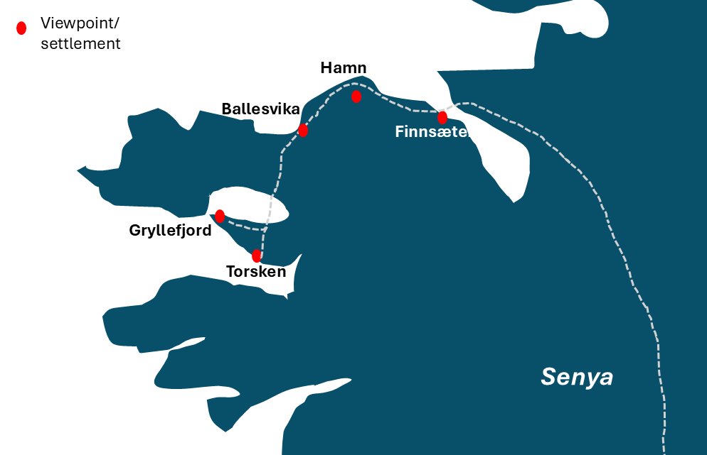
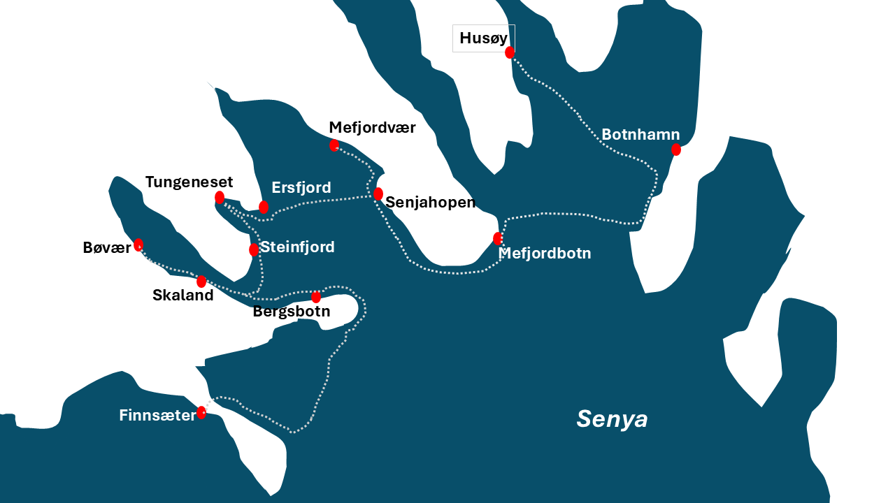
The road along Senja’s northern coast, from Botnhman to Gryllefjord, is designated as one of Norway’s National Tourist Scenic Routes. These are 18 road routes across the country with particularly interesting, unusual or stunning scenery, equipped with viewpoints and pullouts. I’ve added information for photographers about the entire Scenic Route. I’ve divided the route into east and west - here are quick links to specific areas:
SkalandEvening and sunset photography locations
The Scenic Route runs along the northwestern coast of Senja, so afternoon and evening are great choices for landscape light throughout the entire Route. My personal top picks for for sunset/golden hour photography would be:
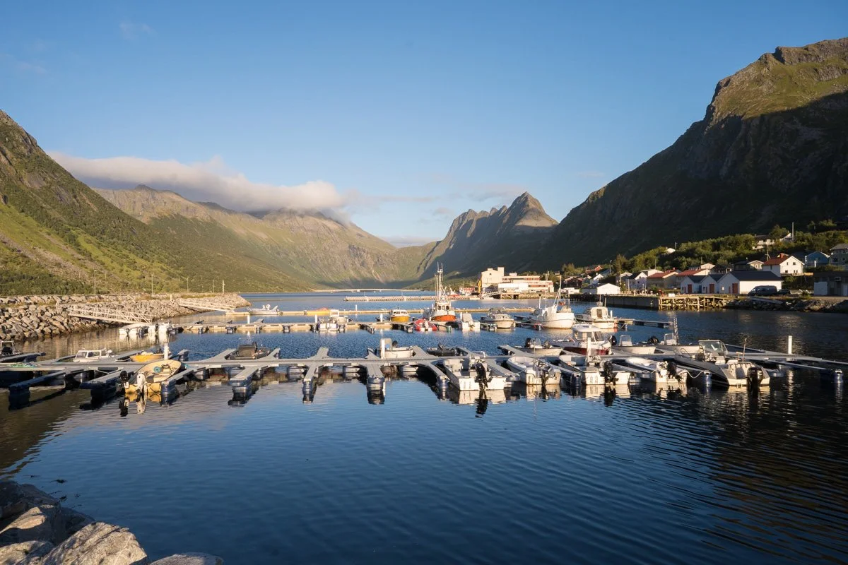
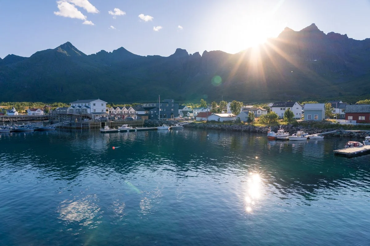
Skaland, for details like piers, cabins, set against mountains across the water, all at their best at sunset
Gryllefjord, for a fjord with the sun shining directly down its length (bear in mind that the sun disappears behind mountains before sunset itself, though)
Hamn, to watch the sun set over lots of small islets
Tungeneset, for Senja’s famed rocky shore viewpoint, best at sunset
Finnsnes to Finnsæter
Svandalen Naturreservat
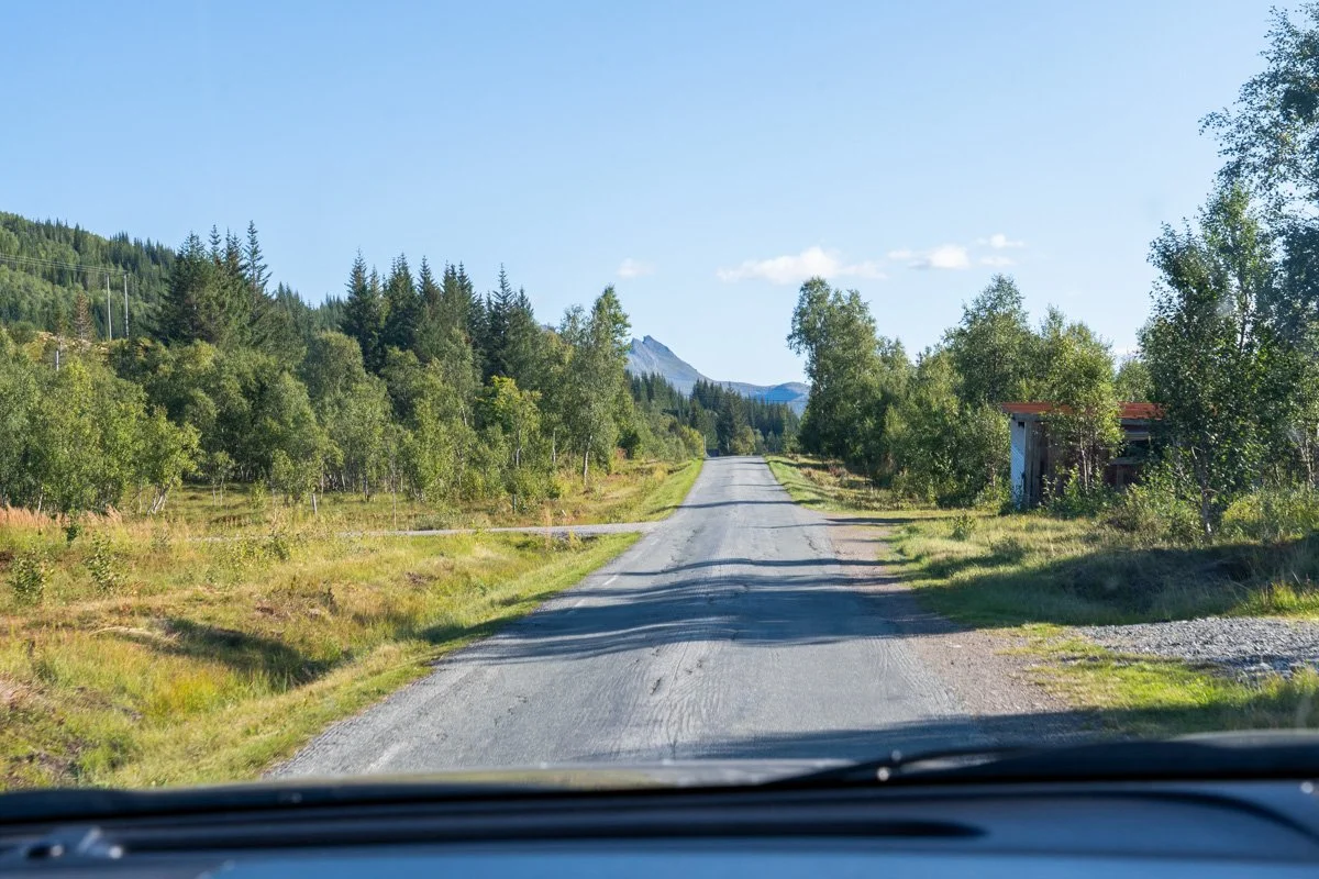
Leaving Finnsnes on the mainland, it’s about a 45 minute drive across the island, to join the coastal route at Finnsætter.
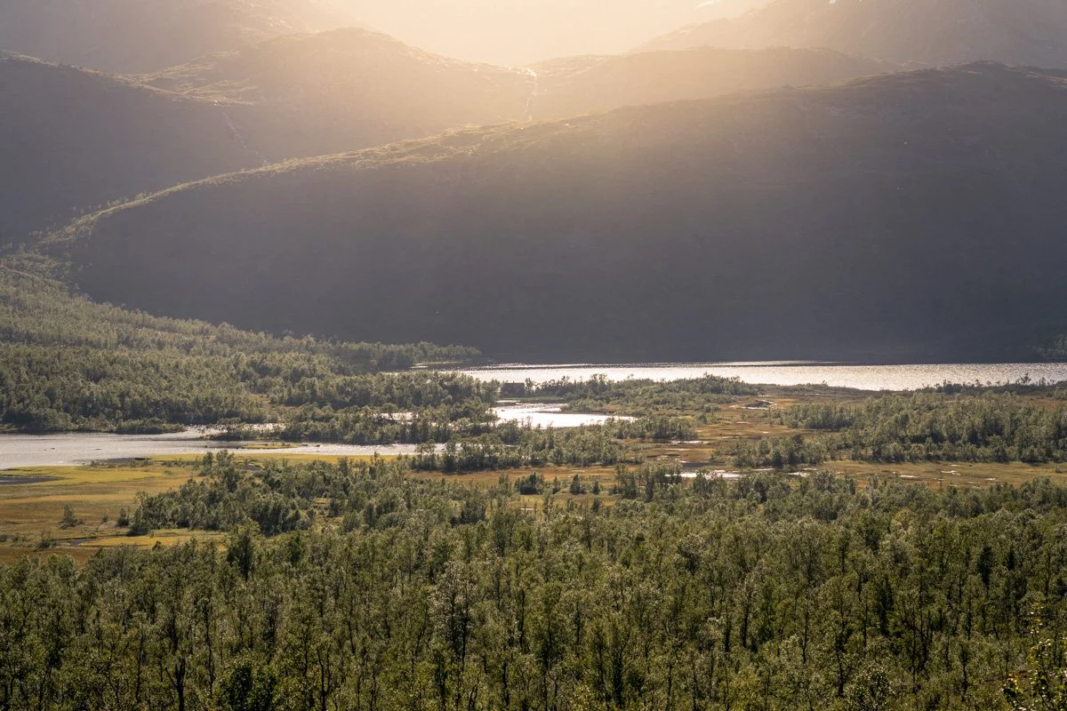
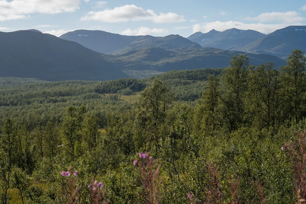
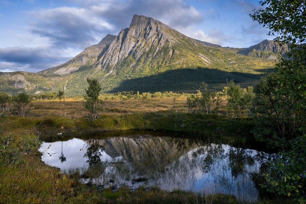
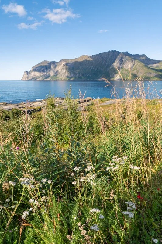
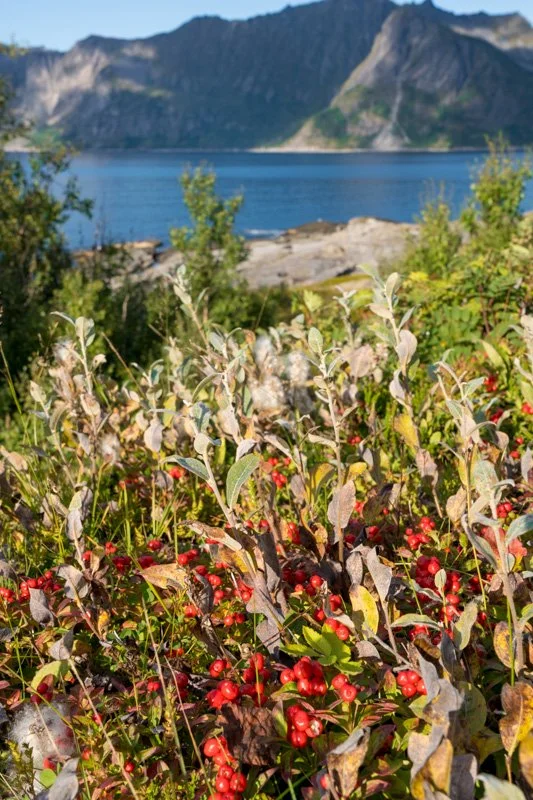
The interior of Senja along this route is Arctic moorland packed with low trees – white-trunked Scandinavian silver birches - and in late summer, carpeted with pink flowers or red Arctic berries. The countryside is at first gently rolling, then it opens into a wide valley with hills and distant lakes to the west as you pass by a nature reserve, Svandalen Naturreservat. There are a few pullouts where you can stop and admire the valley view.
In late summer the sun descends behind the mountains on the west. If you cross Senja in the afternoon on a sunny day, the sun will be shining onto your face as you stop on the pullouts, and the distant mountains themselves will be silhouetted, with the sun coming over their tops. This can create some quite pretty views of backlit pink grasses or treetops if you can crop out the sky. In full sun, though, it makes for quite contrasty scenes.
In the morning, the sun will be coming from behind you or over your shoulder, so the mountain faces may be able to catch the sunlight.
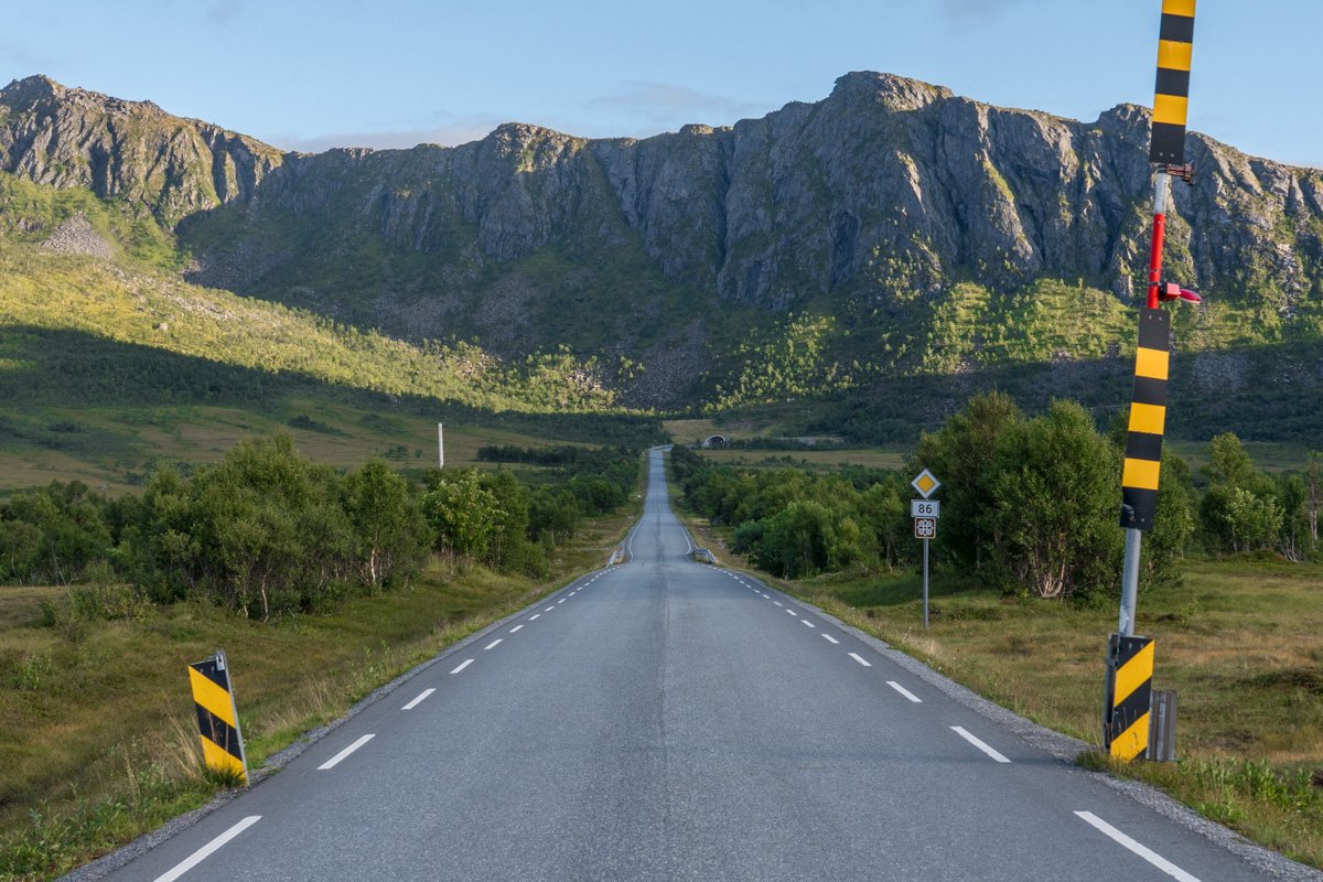
The road continues, passing rushing turquoise and white rivers backed with open views and wide valleys, before curling around towards the western mountain range at the coast.
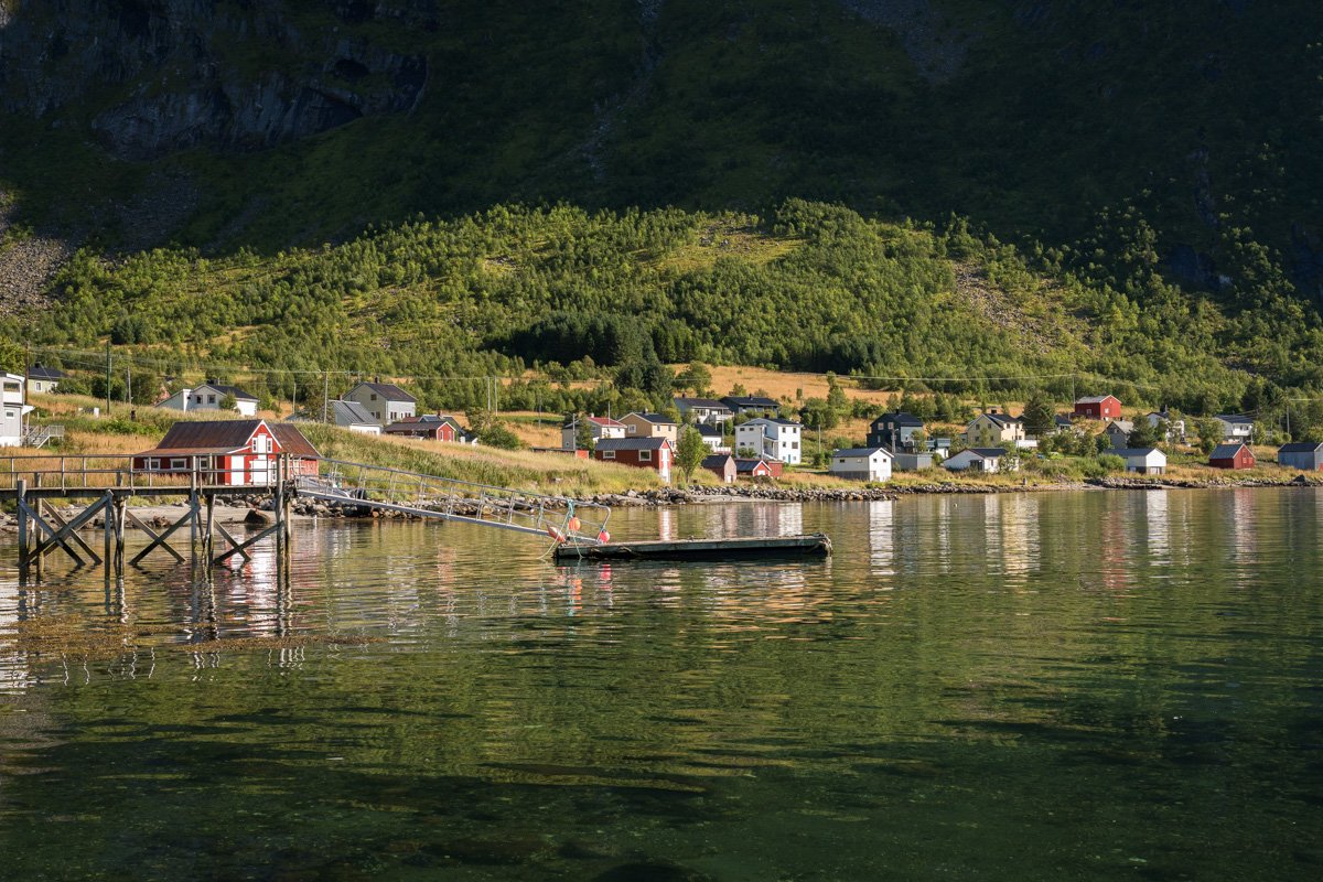
Finnsæter
Finnsæter
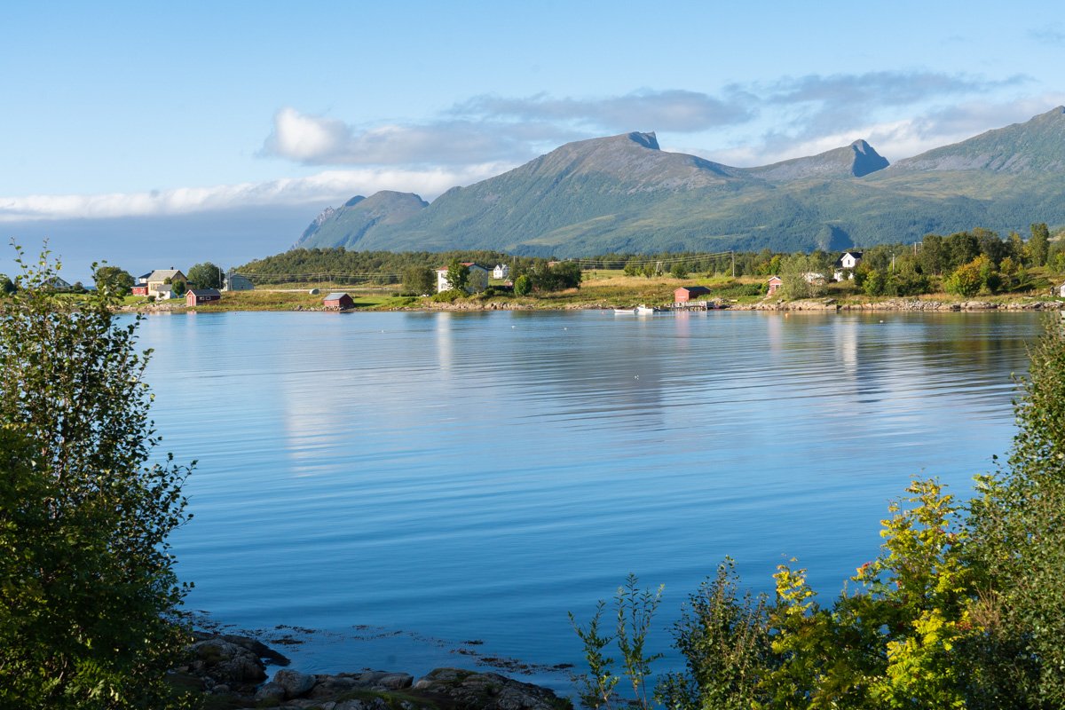
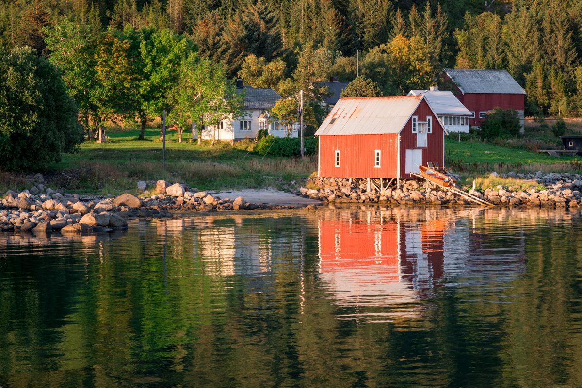
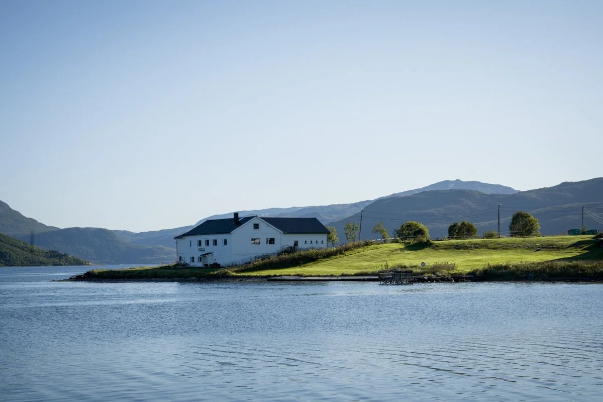
Just before Finnsæter, there is a bridge over the river, followed immediately by a picnic area with parking at the roadside. Here there are views of the mountains of Skaland in the distance, and red cabins on a spit of land in the foreground. This is an incredibly peaceful spot on a calm day with low winds. If you stop at the picnic area in the afternoon or evening on a sunny day you will have the sun coming over your shoulder from the direction of the sea, and illuminating both the mountains and cabins in rich side light.
From here you have a choice:
go west: turn left towards Gryllefjord, or
go east: turn right towards Husøy.
We’ll look at the route to Gryllefjord first, then the route to Husøy afterwards.
The west: turning left towards Gryllefjord
If you turn left here and drive non-stop it’s around 15-20 minutes to reach Gryllefjord, and another 5-10 minutes after that to reach the end of the road in Torsken.
View from Hamn
Hamn
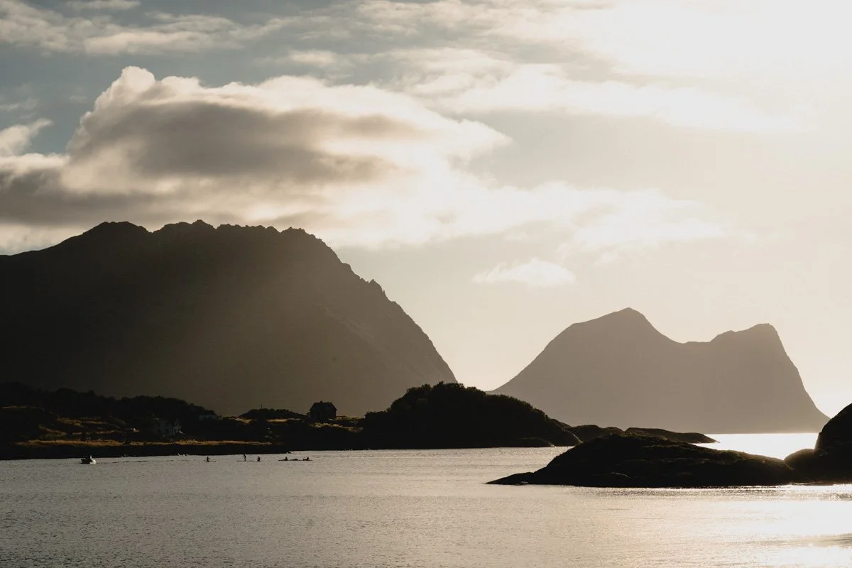
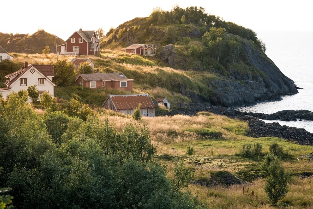
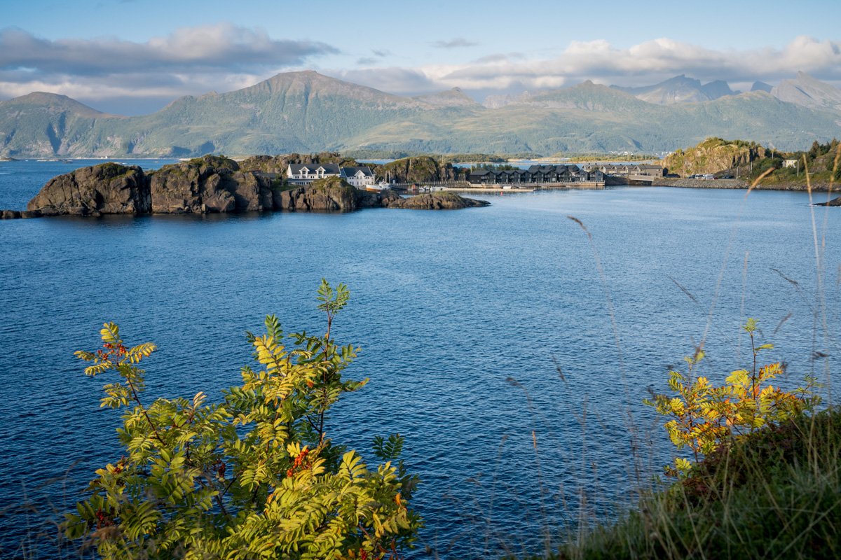
The first stop you reach is Hamn, a tiny island connected by a narrow, but short, causeway lane from the main scenic road. The island is covered by a resort of glossy cabins, their backs to the open sea and glass-fronted faces over a sheltered bay looking back to the mainland, where cliffs drop steeply to the sea. The whole area is dotted with hundreds of tiny islets and rocks.
In one direction, there is a view of the steep mountain faces of Bøvær in the distance. And in the other, the back of Gryllefjord. This is a particularly lovely spot in the afternoon and evening on a sunny summer day, when it catches sunlight until very late and views up and down the coast are lit during golden hour. Any seaspray you can see at the bottom of the distant cliffs will be sidelit late in the day (if the sun is out).
The island itself is mostly covered by the resort, but it’s possible to walk out to a few tiny rocky islets, passing the reception, bar and restaurant (you can go in for a drink or meal). If the weather is good there are likely to be paddleboarders or canoes somewhere in the bay and small boats tied up in rocky nooks. There’s also the possibility to photograph the sun setting behind a series of steep cliffs up the coast, washed with backlit seaspray.
The sun sets behind Gryllefjord in summer and you can watch it here from inside the bar, or from the sun-drenched terrace in good weather.
Hamn
Continuing along the main road from Hamn, the road climbs slightly and there is soon afterwards a headland with a bus stop and pullouts, giving a great view of the coastline north and south of here. The headland is elevated above Hamn and has good views back towards it, with a backdrop of distant mountains. The sea is filled with tiny islands.
The sun sets over the sea here, and the views up and down the coastline, where mountains, cliffs and headlands are lit by the setting sun, offer plenty of potential. It’s another good place to watch a sunset. In retrospect, I wish now that I had tried a long exposure here.
View from Hamn
Ballesvika
Leaving Hamn behind, you turn another corner on the coast and drive into a wide flat valley with steep sides. The road leaves the sea behind and heads inland, straight towards the back of the valley where a tunnel pierces the wall of rock. Before you get there, though, it’s worth exploring this valley.
There are a couple of places to stop and park safely so that you can explore. If you are unlucky, the clouds are low and you can’t see the view. But on a clearer day there are some great views of the mountains surrounding here, with pools and streams and wildflowers forming interesting foreground. The valley opens almost due north; the mountains to the east of the road (the more interesting view) receive nice light in the afternoon and evening – although the sun disappears behind some peaks before the actual sunset time.
Ballesvika
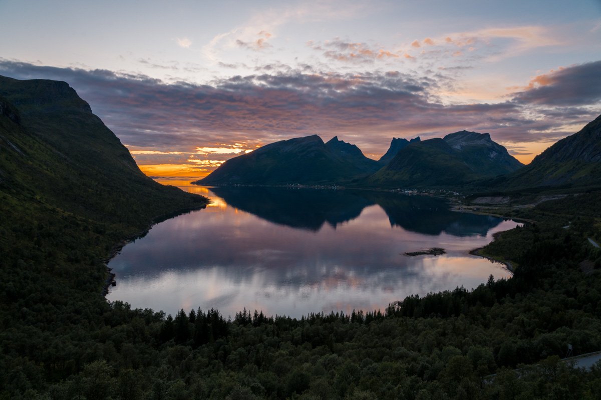
Gryllefjord
Gryllefjord
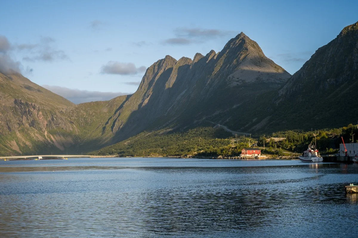
At the back of the Ballesvika valley, the road disappears into a longish tunnel, popping out suddenly at the back of a long narrow fjord. It’s a classic fjord shape – steep, cliff-sided walls, and narrow, it runs fairly straight for a mile or so and has salmon farms half way along. The fjord has an elbow, though - it turns a corner before it opens to the sea. As a result, the whole fjord feels almost completely closed in when you are standing on the waterfront, and water is calm and sheltered.
Facing west, Gryllefjord catches the sunlight quite late. It’s great in the afternoon/evening when the sun (if it’s out) will be shining straight down the fjord. That does make it quite difficult to drive towards the village, though, due to dazzling low sun. The sun itself disappears behind seaward mountains about 1 hour before actual sunset, but the sunlight still catches on mountaintops above Gryllefjord after this to give an alpenglow.
Although facing west, the fjord does also catch some morning light, though – on a sunny day the sun lights up some part of the fjord pretty much all day. The eastern (landward) end of the fjord receive sunlight by late morning in late summer (check an app like The Photographer’s Ephemeris for guidance at other times of year).
As you enter the fjord across the modern road bridge (after the tunnel), you have two choices: follow the road up a series of hairpin bends uphill, towards the town of Torsken; or drive down the length of the fjord, to the town of Gryllefjord. Let’s talk about Gryllfjord first, then driving up the hairpins to Torsken.
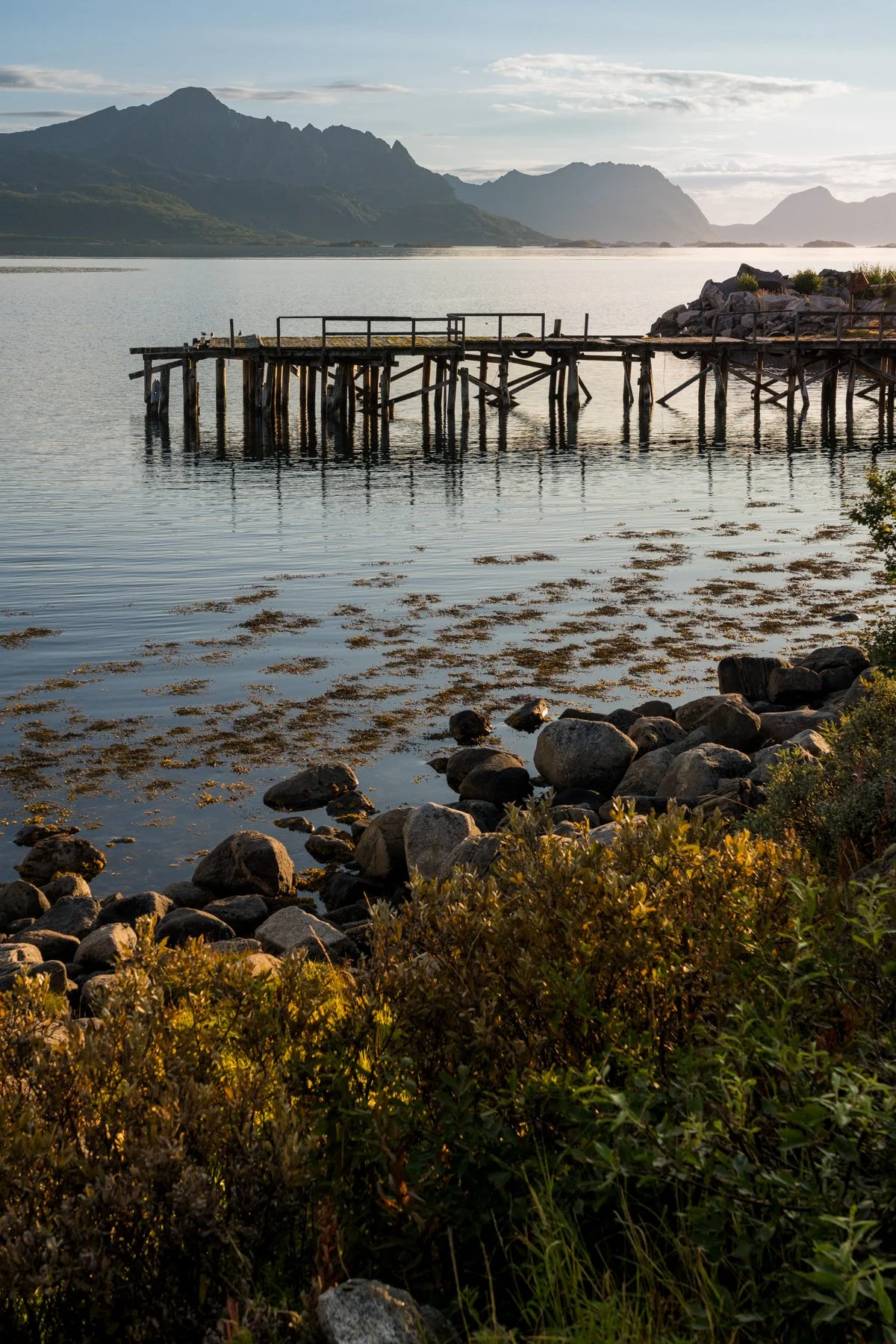
Gryllefjord is a working town, with some industrial processing plants. It’s got a capable, bustling sort of feel to it which I really like. There’s a small shop here and a couple of places to buy a coffee, so it’s a handy place to know about. The town itself really bustles into life during the summer season, when it acts as the port for the summer-only tourist ferry to Andøya. In fact, rhe Norwegian Scenic Route Senja officially starts at the ferry terminal and runs from here along the coast to Botnhamn. Several times a day, fresh boatload of arrivals roll off the ferry and out into Senja through Gryllefjord town, while a solid queue of cars and campervans waiting for the outbound trip fill Gryllefjord’s small ferry port, pretty much all summer. If you are thinking about catching this ferry, there are some important things to know first.
Gryllefjord
As far as photographic opportunities, I prefer to look to the fjord with its reflections and steep sides, and there are several ways to view it.
In Gryllefjord town there are cabins on wooden pilings at the water’s edge, and several piers where you can walk out into the middle of the fjord. Taking a walk here is a nice way to kill some time while waiting for the ferry. On a calm day there are fantastic reflections here in the town’s little marina and it’s a good place to photograph the fjord from the water level. You would need quite wide lenses (or to take a panorama) to capture the entire fjord view, but bear in mind that the view is slightly marred by a modern industrial processing plant in the middle of the town, that you might prefer to crop out.
To view the fjord at its best, leave the town and retrace your route to the main road. This time, turn right drive uphill, up the hairpin bends. There’s a spot halfway up, where you can take a picture, which is well off the road itself. Clearly (as this is a hairpin corner on a steep road) you must not obstruct the road itself. There is a pullout and parking at the top of the hill instead.
If you can make it to the viewpoint, there is a good view down the length of the fjord from here – I think it is the best view in Gryllefjord. You can also look down over the modern bridge and tunnel below you.
Come in afternoon/evening for sun shining down the fjord – but remember that the sun disappears from view an hour or two before sunset itself. Come in late morning/middle of the day for the sun shining on the opposite walls of the fjord.
Gryllefjord
Torsken
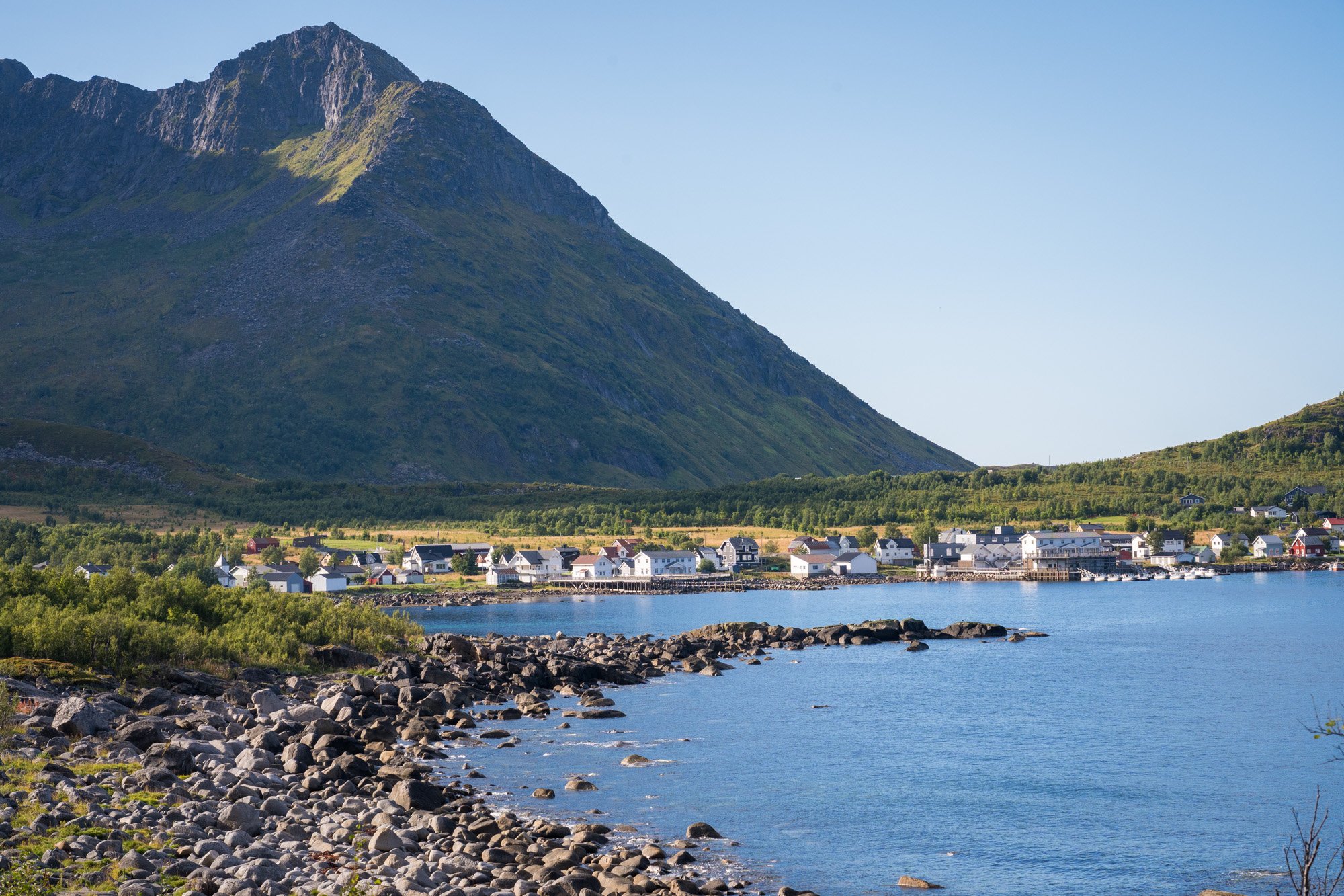
If you continue up the hairpin bends from Gryllefjord, you will drive across some rock-strewn moorlands and over a pass towards the fjord next door. After about 10 minutes, you will be following some more curves downhill into the village of Torksen, on the other side of the cliffs from Gryllefjord. Torsken is not on the official Norwegian Scenic Route – which starts at the ferry terminal in Gryllefjord and then heads north. As a result, Torsken feels somewhat quiet and off the beaten track. It’s a nice contrast to Gryllefjord’s regular bustles of ferry traffic during the summer season.
Torsken’s fjord is curled and rounded - more like a bay than a fjord. And Torsken itself is a small hamlet that faces south-east, with the wall of mountains curled around its western side like a hug. On a sunny morning, the village is a sheltered suntrap. As a result of all this, it’s a lovely place to stay, especially if you like to enjoy a morning coffee on a sundeck in the peace and quiet, without ferry traffic trundling past. Although it is “off” the scenic route, though, it is only a few minutes over the pass into Gryllefjord, and Torsken is home to some rental cottages, as well as a resort with a restaurant and cafe.
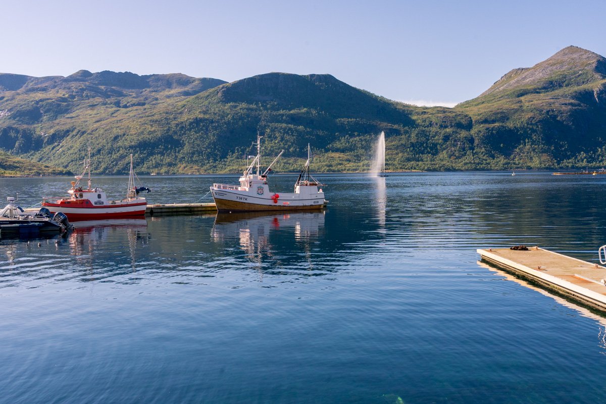
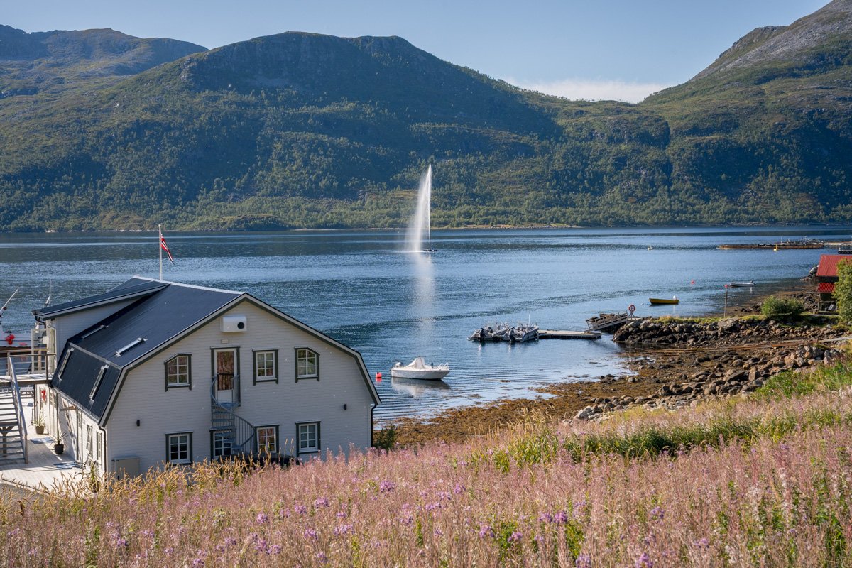
Torsken
In front of the village itself is a giant, Geneva-style fountain in the middle of the fjord. At the northern (seaward) end of the village is a little viewpoint area, with a west-facing bench offering a view out towards the sea. The lovely village church, a wooden building painted red and mustard, dates from the 1740s and is easy to find.
Although it’s superb in the mornings with its south-east face, Torsken’s fjord is rounded and also receives light very late into the evening. In summer, you can sit in the village to watch mountains across the water shining in the evening sunlight. If it’s clear enough and there are no clouds on the horizon to obscure the sun, you might see alpenglow around sunset, as the sun does not disappear behind a mountain before it sets here for much of the year.
Although it’s a nice place to be based – very peaceful, sunny and pretty – I found it hard to make a killer landscape composition here, though.
There is a hike that goes up from Torsken, over the mountain top and down to Gryllefjord in the next door fjord.
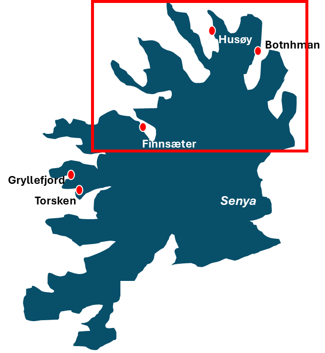
The east: turning right towards Husøy
This section describes the Norwegian Scenic Route heading eastwards, from Finnsaeter towards Husøy.
Finnsaeter to Bergsbotn
From Finnsaeter, the road heads upwards past some sparsely-wooded moorland, dotted with low birch trees and carpeted with red lichens and Arctic berries in late summer. At the top are a series of two mountain tarns, each with a place to pull out.
Although the tarns are very pretty, I found it difficult to make a composition, as the first one especially is small without a major view. A wideangle lens would be useful if you want to look for a composition here, but I preferred to prioritise my time elsewhere instead.
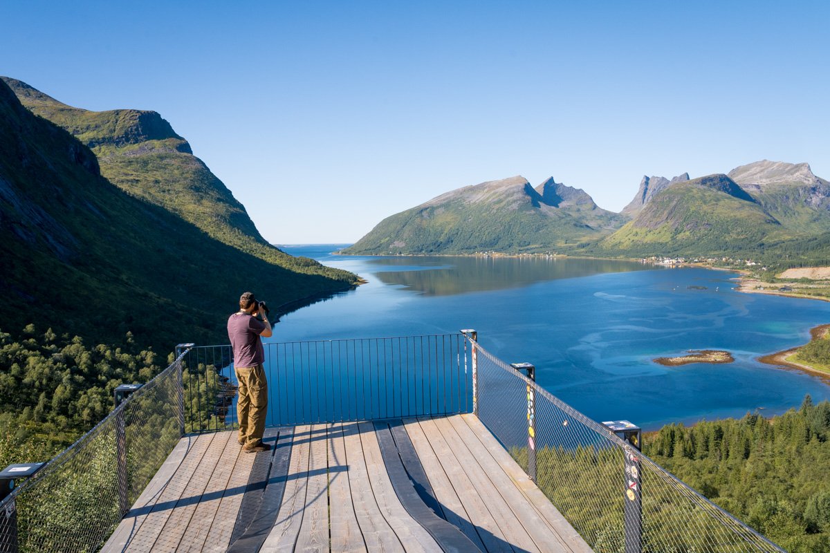
Bergsbotn platform
Bergsbotn
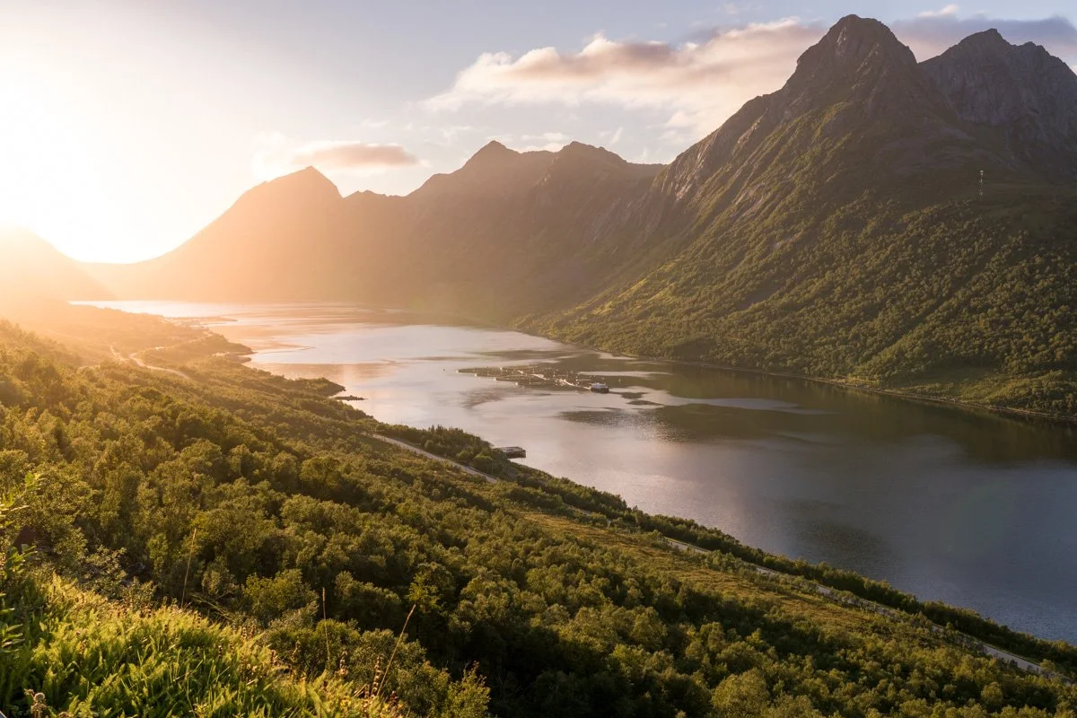
Soon after, the road slides through a narrow pass with mountains above on both sides, and then pops out high about Bergsbotn, a viewpoint with a dramatic cantilevered viewing platform (and toilets), at the back of a north-facing fjord.
This is one of the classic, famous views of Senja. The fjord has a relatively narrow entrance to the sea, but from here it appears to widen into a rounded bay – a perfect horseshoe shape - laid out at your feet. There are high cliffs on your left, stretching above your head. The road zigzags down a series of hairpins below you, down the water’s edge, and then it follows along the curve of the bay below through pine trees, eventually reaching a series of distant hamlets that you can see on the far shores. It’s a relatively sheltered area and the water can produce very nice reflections.
This is a classic and beautiful viewpoint. I captured the entire view the wider end of my “general purpose” lens – you may not need an actual wideangle lens to capture it. The classic view is taken from the viewing point, which is a fantastic cantilevered platform projecting out over the mountain edge, featuring pretty curves of wood. It’s quite a cool architectural feature that could be incorporated into a composition for scale if you want. It also makes it easy to take photographs of people in the view. However, it does mean that you are somewhat removed from other forms of foreground, and it’s hard to explore this area for alternative views.
Bergsbotn platform
Contrast can be a key challenge here. The famous viewpoint itself is in full sun in the middle of the day. The cliffs on your left face almost due north, and are usually in shadow, while the distant shores and mountains are south-facing, and receive plenty of light. Middle of the day in summer can produce very strong, harsh light if there are not enough clouds to filter the sunlight.
The viewpoint faces roughly north west and so is a natural choice for afternoon and sunset. However, be aware that direct light is lost from this viewpoint before sunset, because as it sinks, the sun strikes the mountains outside the fjord, but not inside. This means that foreground and mountains around the bay can be very dark, but the sky and water are still bright - a difficult contrast. The road following the shoreline is visible on your right – if you bring a tripod (and possibly an ND filter) you might be able to produce some long exposures with light trails of the vehicles driving past. I did have a go at doing this during blue hour but didn’t manage to capture anything properly as I did not have my ND filter.
Bergsbotn
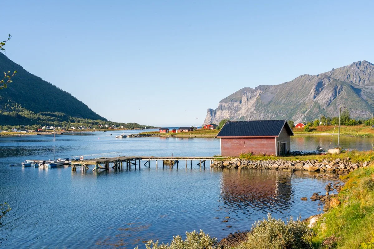
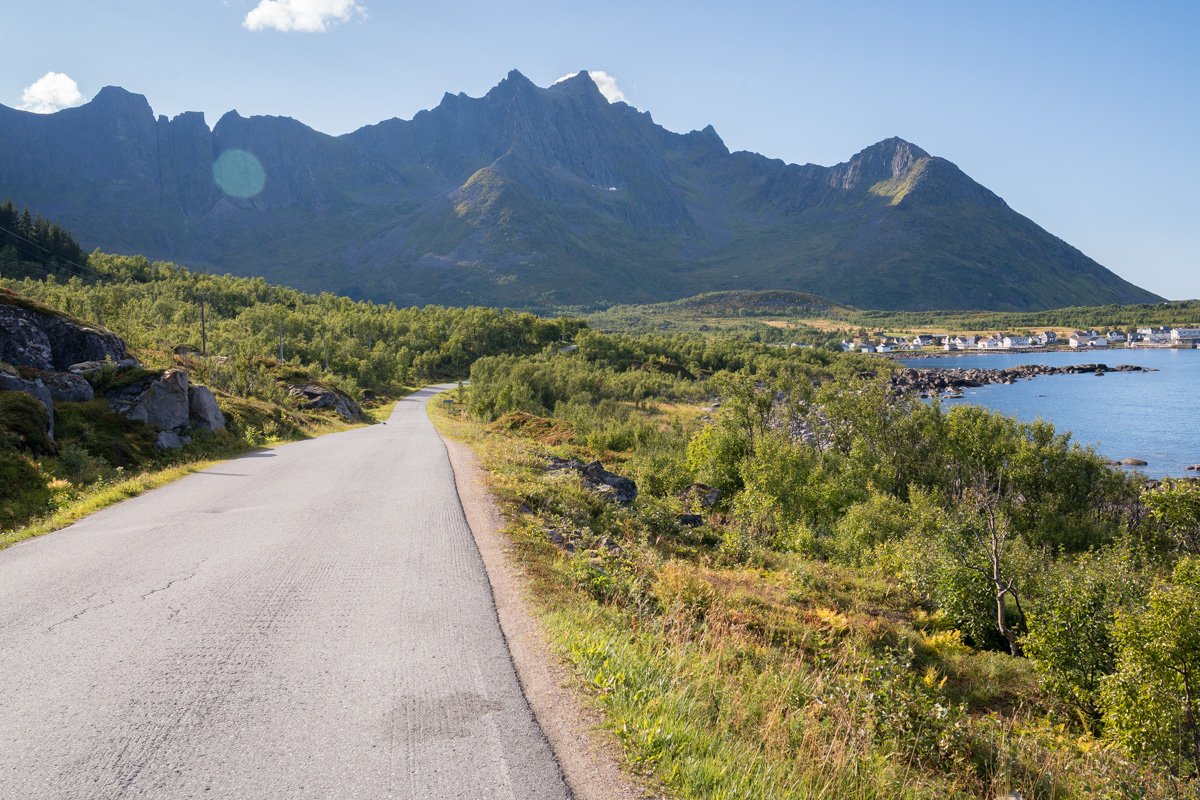
Leaving the viewing platform behind, you drive down a series of bends towards the water and then follow the shoreline. This is a long hamlet of houses, scattered along a stunning waterfront that faces steep rockfaces dropping sheerly into the water. The water here is fairly sheltered and can produce nice reflections (it’s the same water you looked at from the viewing platform above). The rockfaces across the water here look great in the middle of the day and in the afternoon, when sun falls across their fronts. They particularly catch the last of the summer sun in the evening, glowing pink towards sunset if there is enough sun. Unfortunately, it’s difficult to park or stop here – there are no pullouts, and people do actually live here, so it’s important to be careful about accessing the waterfront so as not to trespass or disturb others. I parked elsewhere and walked here.
Half way along the road to Skaland, you reach a junction: you can continue along the Norwegian Scenic Route, which turns sharply right and begins a series of hairpins up a steep slope towards Husøy. However, I recommend taking a detour away from the Scenic Route for a while, and heading straight on toward Bøvær.
There are a few possible places to park safely near these crossroads. If you continue towards Bøvær you will reach a small shopping area and beach with plenty of proper parking.
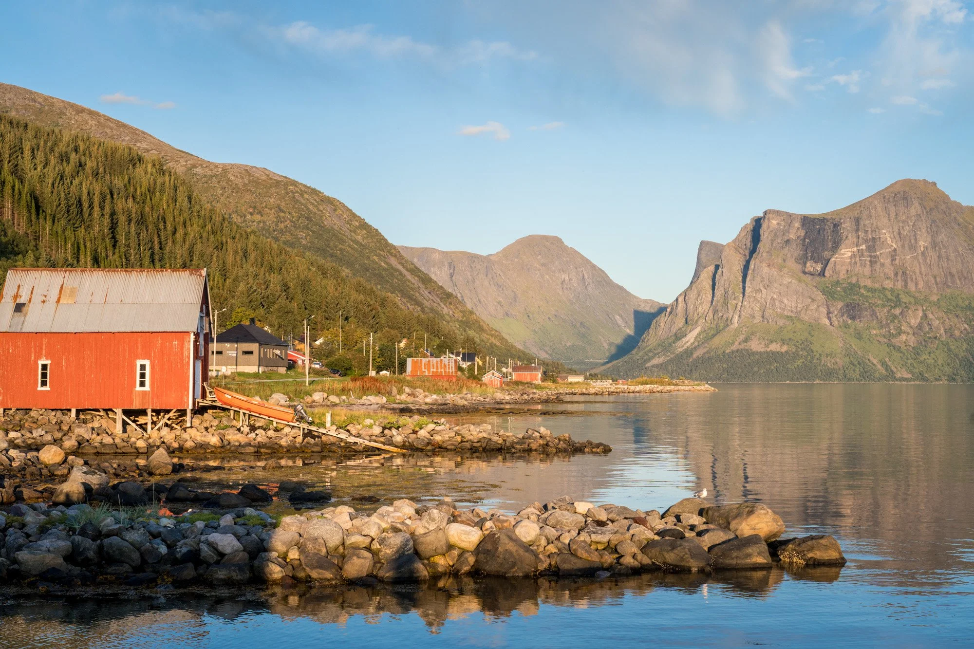
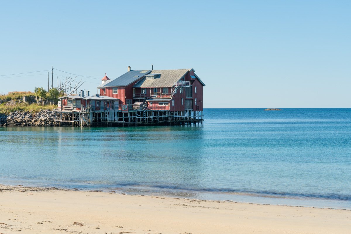
Skaland
Skaland and Straumsnes
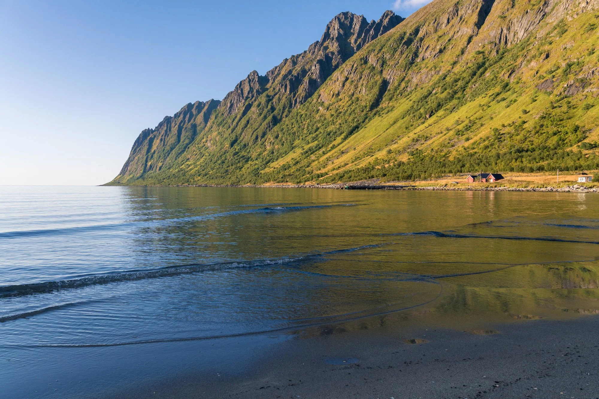
If you continue along the waterfront, you will reach the long, skinny villages of Straumses and Skaland.
Skaland village itself is useful to know about, as it has a 24 robotic Joker (grocery shop). The area around here does offer some nice photographic opportunities, and there are plenty of places to park. This area is particularly lovely in afternoon/evening on a sunny day, as it’s drenched in sun til late. There’s a lovely little white beach, backed with a lush grassy park. The beach faces south west, and across the water are the distant mountains around Hamn and Gryllefjord.
The villages here stretch out along the waterfront, dotted with red boat cabins and wooden piers – some still in use, and some abandoned and crumbling. On a calm day the shallow water fringing the village beach is glassy smooth and reflective, dotted with rocks that can be used to make compositions, with distant mountains across the water and the sun setting over the sea. Directly behind the Joker itself there is a small marina, with sheltered water that produces nice reflections, and a small parking area popular with campervans.
If you stand on the shore and look inland, towards Steinfjord, the afternoon sun is behind your shoulder, lighting up the fjord. Turning towards the sea – with distant islets and peninsulas visible - you will be facing the setting sun.
I found it worth spending some time here in late afternoon walking slowly along the water line, looking for compositions. There are loads of lovely details here, with a stunning mountain backdrop and a shop.
Bøvær
Bøvær
If you continue along this road (which I highly recommend) you will leave Straumsnes and continue along the shoreline. The road transitions from the modern, well maintained surface into a tiny back road, a little bit bumpy and worn here and there. Drive carefully – the road is narrow and wriggly. It’s relatively quiet, but not deserted, and on a sunny summer day you will meet the odd vehicle, so keep an eye out for passing places.
The road wriggles through birch trees and scraps of meadow, past a series of tiny coves and beaches with views across the fjord mouth to mountains opposite. The whole area feels quite remote and very bucolic and I really loved it. It feels quite different to the other drives on Senja. There are no “big views” here (like the viewpoints at Bergsbotn, or Tungeneset beach) but there are lots and lots of opportunities to look for interesting foreground to frame smaller views, featuring shorelines, rocks and distant mountains.
After about 15 minutes you reach the end of this particular piece of road, the hamlet and beach at Bøvær. And what a beach! A fantastic - and very quiet – stretch of soft pale sand, lined with some cottages and cabins under the watchful eye of a steep cliff face. The road halts at the cliff foot, where you will find a turning circle to turn around. DO NOT park in the turning circle! All the traffic on this road relies on being able to use it, since the road simply stops here.
Bøvær
There are areas in which you can park behind the beach by pulling off the road, although if it’s a nice day in summer many of them may be taken already. Be very careful not to block the road itself, or any entryways or meadow accesses. Also be careful to choose a solid verge – some of the verges here are lined with ditches, large rocks and even a bog, which may be obscured by grasses and reeds. You don’t want to drive onto a piece of grass only to find it’s actually a ditch. If necessary turn around and drive further away from the beach to park and then walk back. There are toilets at the end of the road.
The beach faces west and the sun shines directly onto the beach in the summer afternoon. At the southern end is a headland curling around to provide shelter, home to some large red fishing cabins. The afternoon sun can make it hard to get shots facing out to sea/mountains as it will be shining straight onto your face. On a sunny day, the midday light can harsh. On the other hand, if it’s the middle of a sunny day you will almost certainly want to be enjoying the lovely beach itself, which is a lovely crescent of white soft sand and turquoise water, dotted with black rock pools here and there.
There’s plenty of opportunity to walk along the beach and find views that incorporate prettily painted cabins or rockpools. Cabins lie dotted around the grassy meadows, with turquoise water as a backdrop.
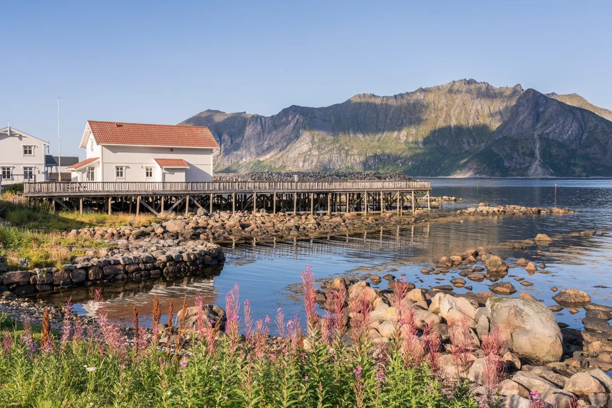
SteinfjordStienfjord
Just before Straumsnes is a crossroads. If you go straight ahead you will eventually reach Bøvær, but if you if follow the main road Norwegian Scenic Route, you will turn right here, hairpinning upwards steeply, and entering a rather creepy old tunnel, which pierces through a mountain and suddenly opens from the darkness onto a stunning beach in the neighbouring fjord.
The fjord here faces north west, and the water is quite protected and sheltered. It’s a steep fjord, where mountains drop steeply into the very calm and reflective water. A smashing beach of soft white sand lines the back of the fjord (at a tourist stop with parking and toilets). Because the fjord is so steep, a shadow is already creeping across the beach by the middle of the day in late summer, so it can be quite chilly compared to other beaches and may be complete shadow for much of the afternoon (try nearby Bøvær for afternoon sun instead). In the middle of the day the sun takes a position just above and behind the mountains on the western shore, and from Steinfjord the dark fjord western walls are silhouetted.
Tungenset
However, in contrast, the eastern side of the fjord is in almost full sun for much of the day (assuming the sun is out). The village of Steinfjord sits on this eastern shore, which is also home to a resort and a wonderful restaurant, the Fat Cod, which has a wooden overwater deck that is a suntrap in good weather.
There’s a tiny boatlaunch and pier here for Steinfjord fishing boats. From this spot there are great views both back inland (towards the beach and mountains) and out to sea, with the mountainous headlands enclosing. The green water is so clear you can stand on the pier and count the starfish on the seabed. It’s one of my favourite areas on Senja.
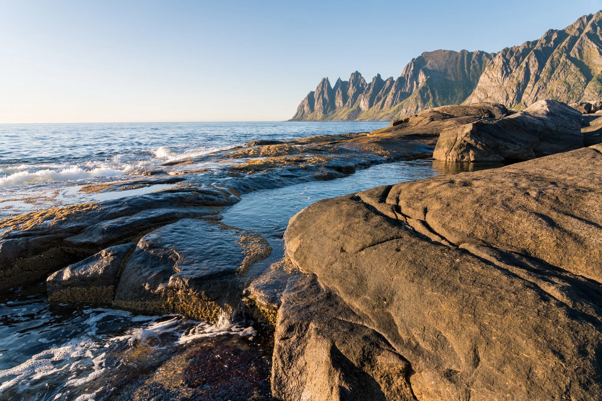
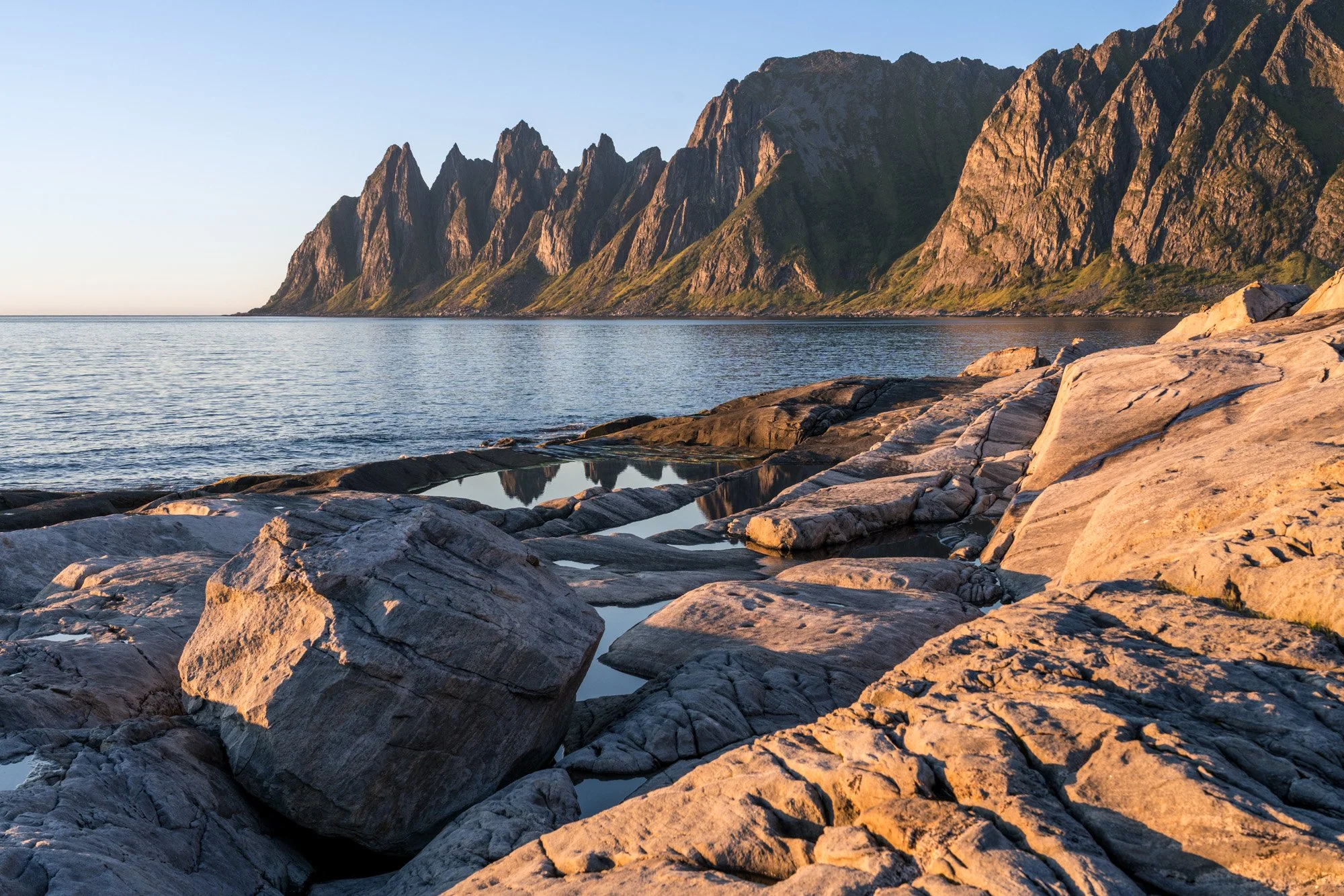
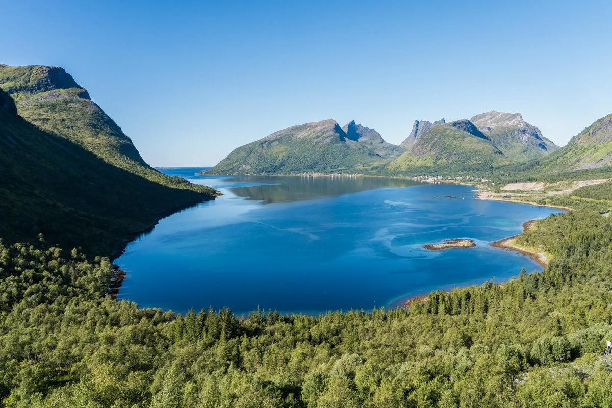
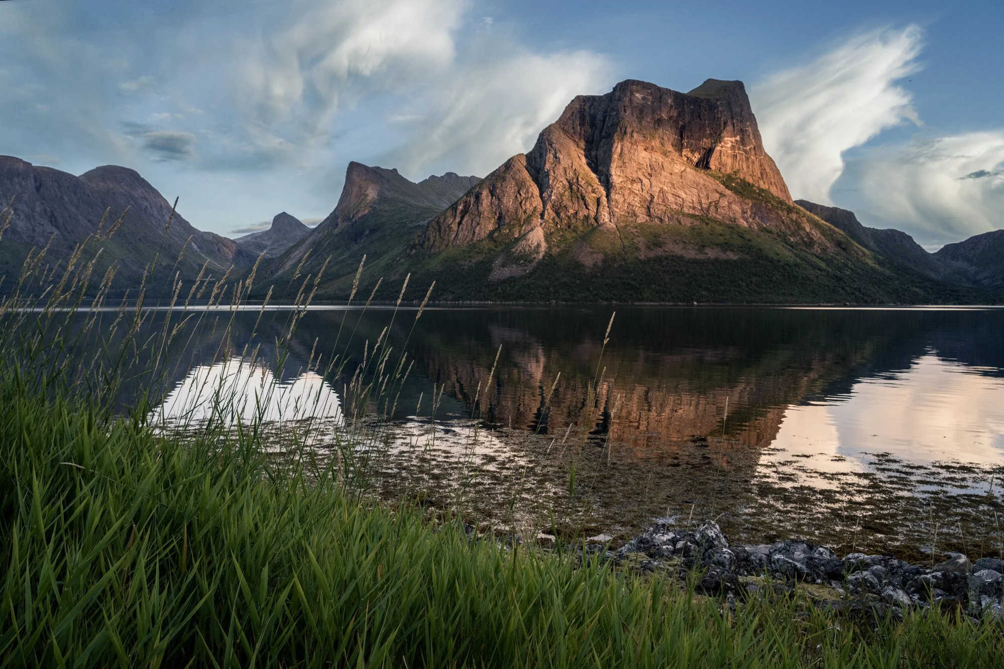
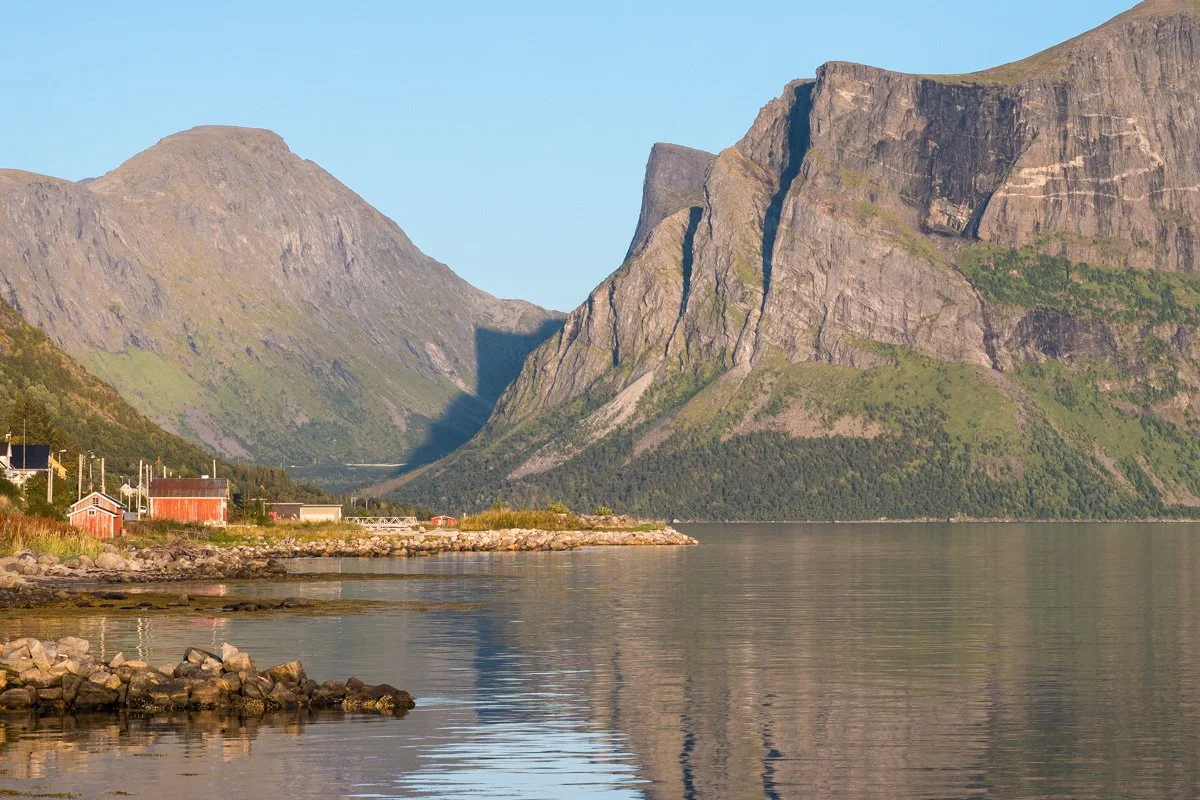
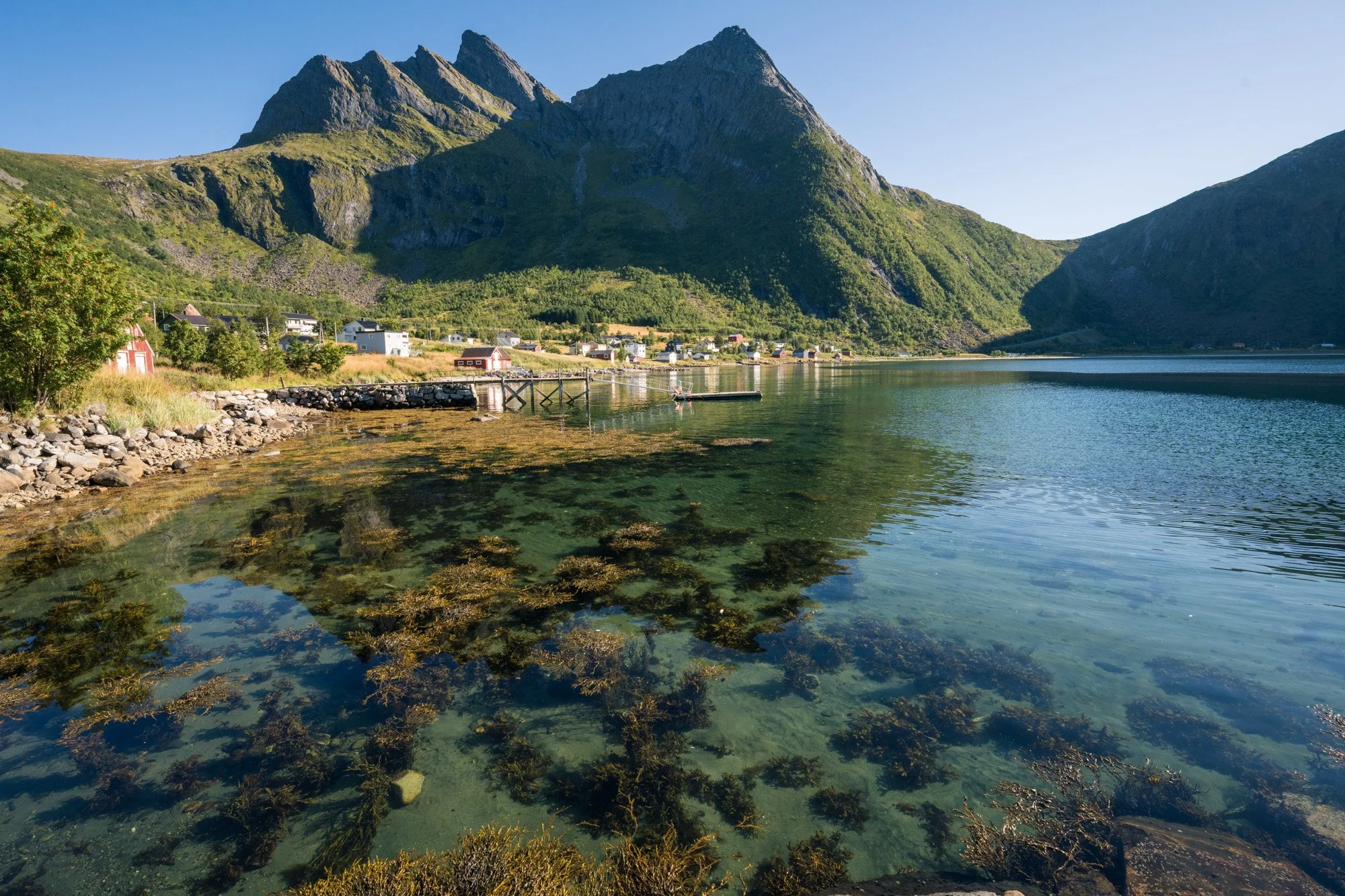
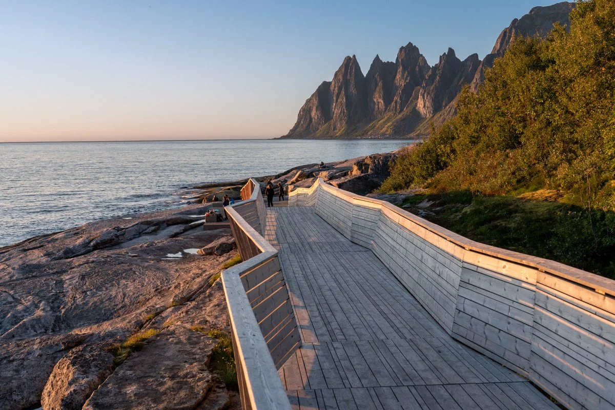
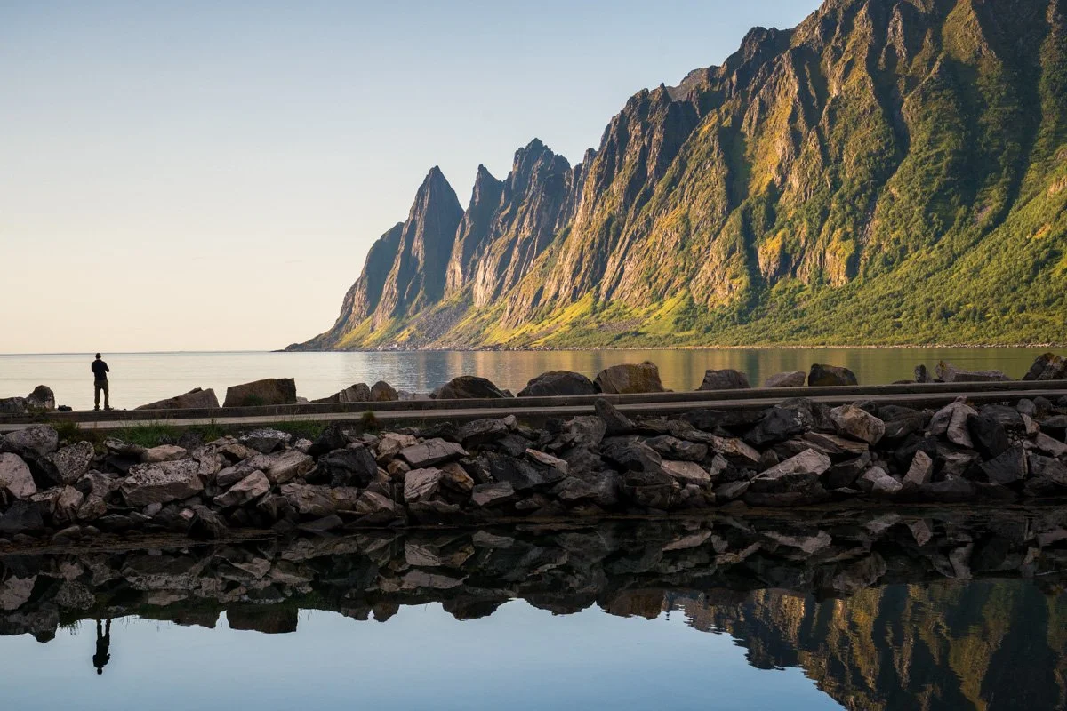
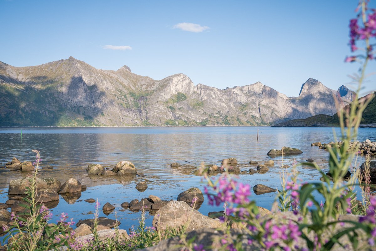
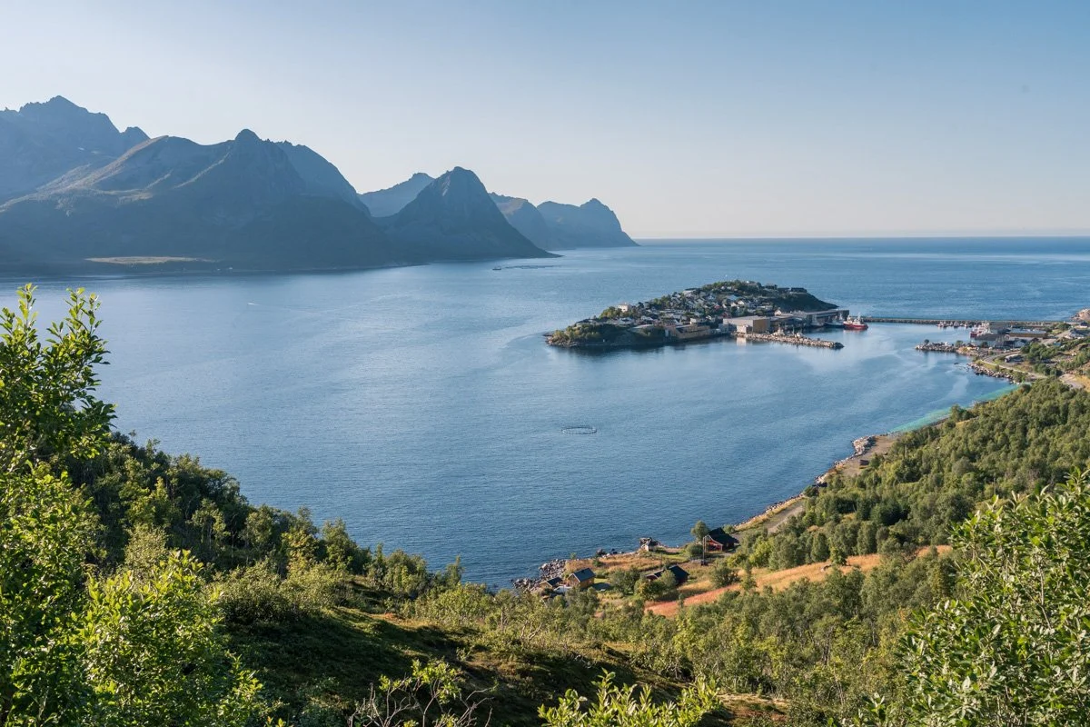
TungenesetTungeneset
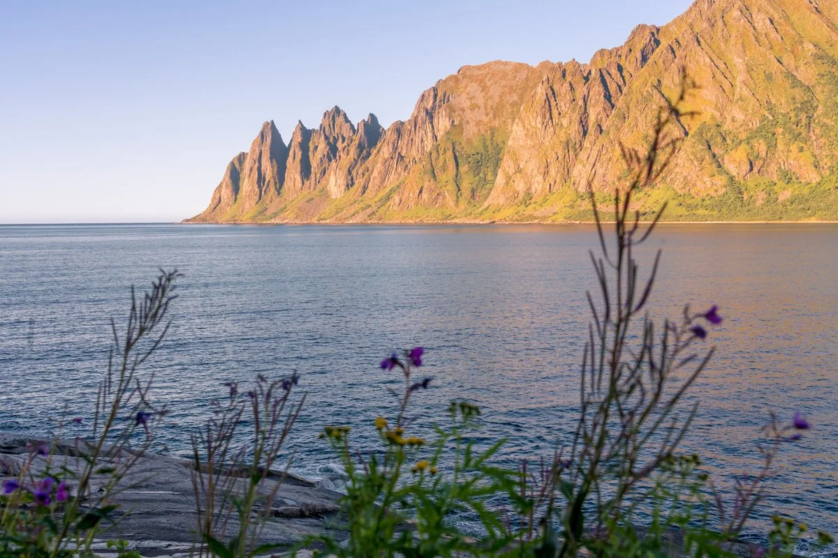
A few minutes away is Tungeneset – another stunning view for which Senja famous.
Tungesenet is a rocky headland, where a series of rocky sheets, pebbles and boulders form a kind of rock beach. If you walk down over the rocks to the shoreline, you can get great views of a jagged range of mountains (the next headland sticking out into the sea) across the water. This is a major stop on the Norwegian Scenic Route, and it features parking, toilets, and a fancy architectural walkway down to the shore, sharp geometric shapes of wood that can be incorporated into your composition if you want. Although this is definitely a stunning location, it’s not easy to find an original composition that features these jagged mountains – the main variables you could play with are the choice of foreground, and the lighting conditions you have on the day you visit.
However, if you don’t mind turning away from this classic view, there are lots of opportunities for other scenes instead. The foreground – a rocky shoreline – has lots of interest with rockpools, leading lines and varying textures. The rockpools can produce nice reflections if you explore the area. Be aware, though, that it is a tidal area and will look different each time you visit, as more or less of the rocky foreshore is exposed.
Tungenset
The beach here catches the sun until almost sunset in late summer, as the sun sets over the sea (check the sun’s location at other times of year). Both the jagged mountains to the north (the background), and the shore itself (the foreground) receive sun quite late into the day. The foreground shore loses light first. If you face the famous view, the mountains behind you (to the south) are in shade in the afternoon.
Obviously rocks near the shore can be slippery and can be wet in any weather – take care and wear sensible footwear (not sandals or flipflops). Keep an eye on the water, as sudden big waves can surprise you, and make sure you know whether the tide is approaching or receding. Don’t go onto the beach in rough weather.
As this is one of Senja’s most famous viewpoints, it can get quite busy, especially at sunset - in fact, these were the biggest crowds I saw during all my time on Senja (although it’s not actually crowded). I never had difficulty parking, although had to wait for a couple of minutes sometimes.
ErsjordstrandaErsfjord and Ersfjordstranda
Leaving Tungeneset and heading east, you will drive around a headland and into another fjord, Ersfjord, parallel to Steinfjord. Like Steinfjord, it also faces northwest. The mountains here are high and drop steeply to the water. The northern side of the fjord terminates in the jagged peaks visible from the Tungesten beach, but they are not easily visible from here.
The fjord terminates in another perfectly arched beach (Ersfjordstranda), a beautiful sweep of soft white sand, and another one of Senja’s top tourist locations. The beach itself is lined with marram grasses which – when the sun is shining – are lit against the blue sea in the afternoon. A small river joins the sea the western end of the beach, where there is a small hamlet of houses and cabins tucked tightly into a corner under the towering rock faces. This is the sunny side of the fjord! This side – and only this side – receives sunlight into late in the afternoon. In late summer it never actually goes into shade until sunset. If there are no clouds out to sea obscuring the horizon, then the light here is fierce in the late afternoon and evening - the entire eastern side of the fjord glows green-gold for hours.
The beach itself, however, gradually moves into shade, from east to west, as afternoon progresses.
Ersfjord
The river pops out from a cute mountain valley, behind the beach, and the Scenic Route crosses it over a bridge just before leaving Ersfjord. This small river valley catches light in the middle of the day - until mid afternoon - and partial light in the early evening. The river itself is a pretty calm flow, that reflects the surrounding peaks. However, despite the lovely light and reflections, I still found it difficult to make a strong composition around the river valley.
Meanwhile on the beach itself, the river swerves across the sand in an S curve and it’s possible to find compositions from the beach that get reflections of the mountains in the river, or use the river as a leading line. Bear in mind that you’ll need to go from the beach back up to the bridge to cross the river, so it takes a little time to explore the area.
At the opposite – eastern, less sunny - end of the beach is a small harbour with some breakwaters that produce mirror-like water. There are great reflections here of the mountains, with boats as foreground, or with people silhouetted on the breakwaters. The harbour (and whole eastern side of the fjord) is in shadow by mid afternoon in late summer, but the opposite side of the fjord is still in full light, and is reflected in the harbour water. On a sunny day, the light reflected in the water is intense, so it’s not too dark.
At time of visiting new carparks were being built, with limited parking along the road. Note there’s no parking at all at the western end where residents live.
MelfjordværMelfjordvær and Senjahopen
Continuing along the Norwegian Scenic Route, you leave Ersfjord via a tunnel punching through another mountain.
The tunnel deposits you in fairly busy industrial fishing village, Senjahopen, scattered across the head of the a tiny but pretty fjord. The fjord here forms a bay which is almost completely closed to the sea – a pair of headlands guarding the entrance to the bay almost touch. Across the water, beyond the headlands, the distant mountains form a solid wall of peaks including Segla and Hesten, location of some of Senja’s most famous mountain hikes; these mountains are in full sunlight all afternoon and into the early evening from here.
On arriving in Senjahopen, I suggest you turn left immediately, following signs to Melfjordvær. The huge industrial fishing buildings here not very promising, but it will be worth it, I promise – this is a lovely little detour.
Passing the industrial units behind Senjahopen, the road takes you through a long village, all meadows and red cabins along a waterfront. Across the water, the dramatic wall of Segla, Hestenand sisters, lies in full late summer sun during afternoon and evening (if the sun is out), forming a beautiful backdrop. However, it’s difficult to find good foreground for unique compositions, despite the dramatic view. Bear in mind that this is a working village and take care not to block any entrances or cause a nuisance.
Senjahopen
Finally, the road turns around a hidden corner and heads almost due west towards the back of the Tungeseten massif. The road ambles for a couple of km along a rocky shore which is stuffed with wildflowers, berries and meadows, with the dramatic and photogenic shape of those mountains forming a backdrop. Low and lush Arctic woodland and spilling wildflowers line the roadside. A the last minute, the road dives away from the mountains and steers into a village (Melfjordvær) sited a curled bay on the sea.
In mid afternoon in summer, the mountains west of the village are thrown largely into shadow, but (if the sun is out) pools of sunlight fall directly onto the village of Melfjordvær, which forms an afternoon suntrap of meadows and cheerful red cabins. In contrast to the jagged shadowy peaks, the foreground of wildflowers and silver birch catches sun along the roadside.
There are loads of opportunities to get shots here:
Looking eastwards (towards Hesten & Segla in sun), with rocky headlands or Arctic berries in the foreground
Melfjordvær village, and its perfect little bay, tucked under the dramatic cirque
The road, heading arrow straight for the shadowy mountains
MelfjordværMelfjordvær sits in a hidden corner, a lovely suntrap catching sun until mid-afternoon/early evening in late summer. On a calm day the water in the bay is mirror-like along the shore of the village, where there is a resort consisting of cabins out over the water and a tiny marina (a restaurant/bar in the resort is open over summer). On the main street is a cute white-painted wooden church. Behind the village, lush meadows dotted with birches and fluffy wildflowers stretch up towards the impassable mountains.
The road continues through the village and terminates in a large carpark which has plenty of space. Nearby is a low headland you can walk out on, to see the village and the fjord better, and there is a trailhead for an short walk to the top of a nearby hill.
Melfjordvær
In late afternoon the sun peers over the tops of the western mountains, and the long grasses and meadows of the village are beautifully backlit if the sun is out. The light on the village itself will be lost in late afternoon/early evening in late summer, as the sun sinks behind the mountains.
There are lots of possibilities here, for compositions:
Views of boats on the marina, looking towards the eastern mountains. The foreground is in sunlight during afternoon and early evening
Backlit meadows with mountains as a backdrop
Painted white church set against a low mountain (although there are lots of telegraph poles in front)
Views over the village itself (you can climb a low hill at the end of the village for a view)
Melfjordvær
Senjahopen to Mefjordbotn
Back at Senjahopen, rejoin the Norwegian Scenic Route and turn left to continue towards Husøy. This is one of the busiest parts of the Scenic Route, as Ersfjordstranda, Tungeseten, together with the hikes up Segla and Hesten, are among the top sights on the island.
The road now curls for some kilometres, hugged tightly between the sea and the steep mountains plunging down to the water. There is no beach here! Dramatic rocks all around. There are stellar views of mountains and water in every direction, while the road twists and turns along the curvy waterline. Frustratingly, this is a busy part of the road, there are few places to pull out and there are no pavements (sidewalks), so admiring the scenery is going to be limited to the passengers in the car (message to drivers: eyes on the road!).
There are a few pullouts – particularly Pumpeneset, although it’s difficult to find original compositions there specifically. There are wide variety of very tempting hikes in this area, though. I was unable to take any due to an injury, sadly.
Finally, the road trails away from the water’s edge and begins to climb. A series of woods surround the village of Mefjordbotn, which involves a turn off the main Scenic Route. You would head this way to hike the famous routes.
Melfjordvær
Mefjordbotn to Husøy
Past Mefjordbotn, the Scenic Route climbs up through into a saddle, passing through pine forests with the Mefjordbotn bay below.
The views disappear temporarily while the road curls inland, passing a few small lakes and Arctic moorland with berries and birches dotted with trailheads. It descends and trails past the head of north-facing Botnhamn fjord – cast into a shadow in the afternoon - and then climbs again, back inland on the way towards Husøy.
At the top of the climb there are sudden and dramatic views of Traelvika fjord appearing on your left. Mountains curl around a neat bay far below while the road still heads uphill. There is a small place to pull out safely here and admire the view. You won’t be able to see Husøy yet – it is around a headland – but it does offer dramatic views across a bay surrounded by mountains. Be aware that by early evening in late summer the sun is lowering directly above the bay, so you will be shooting into the sun from this viewpoint, making the scene very contrasty; earlier in the day might be better for photography, with sun coming over your shoulder.
Traelvika
The road then disappears into a tunnel. Popping out the other end, it begins to descend back down to sea level above another inlet, and Husøy will come into view. Husøy is a island in the Traelvika fjord, connected to the eastern shore of the fjord via a causeway that creates a protected, sheltered harbour. The fjord faces almost due north here, and as you approach you are facing Husøy and the open sea behind it, with fjord walls enclosing it to the east and west.
The road begins to hairpin downhill, giving clear views over the whole scene. There is one place to pull out – it has plenty of car parking spaces and an interpretive sign providing information about the area. From this spot there’s a great view down towards Husøy and its surroundings below you. In sunny conditions this can be quite a contrasty scene – with sunlight reflected from the water - but in the afternoon nice side light is coming from your left. Sun will be lost behind a mountain before sunset itself, though.
Husøy
Husøy is a tiny island just off the eastern side and connected by a causeway.
The entire island is covered by a fishing village, with a central square and a couple of long streets. You can park before crossing the causeway – there is a proper carpark, and you can then walk the short distance across the causeway. Alternatively, you can also drive over the causeway and park immediately on reaching the island, where there’s a small carpark.
I suggest avoiding trying to drive around the island if you can avoid it, unless you are staying here – parking is limited elsewhere in the village and it’s small enough to explore on foot. Expect to take an hour or two at least exploring.
Husøy
The whole village is lovely in the evening, as it catches sun in the afternoon and early evening. It’s surrounded by peaks, and being on an island offers a chance to look back on the mountains from the fjord. There are nice views from the causeway in the evening – white and red Arctic fishing vessels are likely to be moored up in the sheltered water, with nice evening sidelight if the sun is out. On a calm day the water here is smooth and mirror-like (unless kids are playing here!).
The village itself is primarily residential and most of the streets don’t provide views – the views outwards towards the water and mountains are occupied by private houses and driveways, so best to keep a distance that respects residents’ privacy.
There are useful facilities, though, and a few viewpoints to explore. There’s a small branch of Joker for groceries as soon as you reach the island. On the northern end of the island there’s a resort with a restaurant, and behind that a tiny, surprisingly short lighthouse, elevated above the surroundings by a low rocky hill and shoreline. You can even stay here.
Botnhamn
As you return from the terminal point at Husøy, you will pass a turning for Botnhamn. Botnhamn is a sleepy, quiet village spread out along a smooth waterfront. This is where the highly dramatic, gnarled Norwegian Scenic Route running across northern Senja has turned a corner and begins to blend into the more gentle landscape of the southern half of Senja island. There is certainly far less drama here! The fjord widens, and the shoreline sinks into low and rounded hills. Houses line the course of the road, and behind them a pretty but undramatic waterfront of lush meadows and verges of wildflowers rolls gently over the landscape. There is a small port where ferries call in, dropping off arrivals from Brensholmen and further afield. When there are no ferries arriving, it’s a quiet sort of place where kids play on their bikes in the road. There are very useful facilities: a charging port, fuel and a small Joker supermarket.
From here you can continue north to the end of the road, reaching a beach at Laukvikenranta. I haven’t made it past Botnhamn yet – driving up here is on my wishlist for next time. However, there’s no particular reason to visit Botnhamn itself unless you need its facilities or are passing through anyway.
Botnhamn
Useful links and sources of information
Here are links that may be helpful:
Good quality tourist information is available at Visit Senja (including where to obtain information on the ground), as well as at the Northern Norway Tourist Board
Heart My Backpack and Life In Norway are both wonderful blogs, packed with heaps of useful information if you are planning a trip to Norway
I wasn’t able to take any hikes myself at the time, but The Photo Hikes Bloghas some stunning photographs from hikes here and the Visit Senja website has useful hiking information
Many tourist businesses here are very seasonal, and may shut down completely for winter (where “winter” can be very long) In my experience, tools like Google Maps can easily get confused by seasonal variations. So check opening hours and operating dates carefully with the business’s own website/Facebook page/Instagram, and be prepared that there may be some impromptu closures on quiet days. I always carry some snacks with me.
If you want to explore Norway’s National Tourist Scenic Routes (Nasjonale Touristveger) you can read about all 18 routes here